ZCZC MIATWOAT ALL
TTAA00 KNHC DDHHMM
Tropical Weather Outlook
NWS National Hurricane Center Miami FL
800 PM EDT Sat Sep 22 2018
For the North Atlantic...Caribbean Sea and the Gulf of Mexico:
The National Hurricane Center is issuing advisories on Tropical
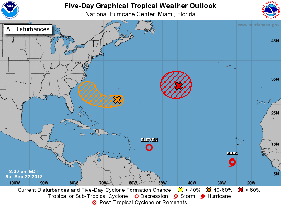
Depression Eleven, located about 500 miles east of the Windward
Islands, and on Tropical Storm Kirk, located well south of the Cabo
Verde Islands.
1. A broad area of low pressure located about 200 miles south-southwest
of Bermuda is producing limited shower and thunderstorm activity.
Unfavorable upper-level winds and dry air are expected to limit
development tonight and Sunday, but conditions could become more
conducive for some development of this system on Monday or Tuesday
while it moves westward and west-northwestward over the southwestern
Atlantic Ocean. By the middle of next week, strong upper-level winds
are likely to limit additional development as the system turns
northward and moves closer to the southeastern coast of the United
States.
* Formation chance through 48 hours...low...20 percent.
* Formation chance through 5 days...medium...40 percent.
2. A non-tropical low pressure system is located about 1000 miles
west-southwest of the Azores. Conditions are expected to become
conducive for this low to acquire subtropical or tropical
characteristics during the next day or so, and a subtropical or
tropical cyclone is likely to form by early next week while the
low meanders over the central Atlantic Ocean. Additional information
on this system can be found in High Seas Forecasts issued by the
National Weather Service.
* Formation chance through 48 hours...medium...60 percent.
* Formation chance through 5 days...high...70 percent.
Public Advisories on Kirk are issued under WMO header WTNT32 KNHC
and under AWIPS header MIATCPAT2. Forecast/Advisories on Kirk are
issued under WMO header WTNT22 KNHC and under AWIPS header
MIATCMAT2.
High Seas Forecasts issued by the National Weather Service can be
found under AWIPS header NFDHSFAT1, WMO header FZNT01 KWBC, and
on the Web at https://ocean.weather.gov/shtml/NFDHSFAT1.shtml.
Forecaster Brown