ZCZC MIATWOAT ALL
TTAA00 KNHC DDHHMM
Tropical Weather Outlook
NWS National Hurricane Center Miami FL
800 PM EDT Fri Sep 29 2017
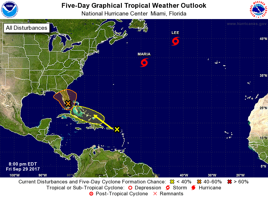
For the North Atlantic...Caribbean Sea and the Gulf of Mexico:
The National Hurricane Center is issuing advisories on Tropical
Storm Maria, located over the Atlantic Ocean several hundred
miles southeast of Halifax, Nova Scotia, and on Tropical Storm Lee,
located over the north Atlantic Ocean about 1000 miles
west-northwest of the Azores.
1. A weak low pressure area over the southern Florida Peninsula is
interacting with an upper-level low to produce a large but
disorganized area of cloudiness and showers extending from the
northwestern Caribbean Sea northward through the Florida peninsula.
Environmental conditions appear to be marginally conducive for some
additional development before the upper-level winds become
unfavorable early next week. Regardless of development, this system
is likely to produce locally heavy rainfall over portions of western
Cuba, the Florida Keys, and the Florida peninsula during the next
several days while the system moves northwestward to northward.
* Formation chance through 48 hours...medium...40 percent.
* Formation chance through 5 days...medium...40 percent.
2. A tropical wave is producing cloudiness and showers over the
northeastern Caribbean Sea and the adjacent Atlantic waters.
There are no signs of organization and upper-level winds are not
currently conducive for development. However, conditions could
become a little more favorable for some development next week while
the wave moves toward the west-northwest. This system is expected
to bring locally heavy rains over the northern Leeward Islands,
including Puerto Rico and the U.S. Virgin Islands.
* Formation chance through 48 hours...low...near 0 percent.
* Formation chance through 5 days...low...20 percent.
Forecaster Beven