ZCZC MIATWOAT ALL
TTAA00 KNHC DDHHMM
Tropical Weather Outlook
NWS National Hurricane Center Miami FL
800 PM EDT Sun Aug 20 2017
For the North Atlantic...Caribbean Sea and the Gulf of Mexico:
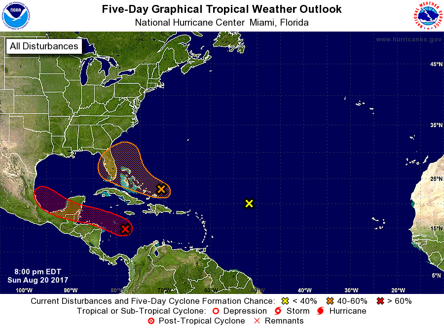
1. Data from an Air Force Reserve Hurricane Hunter mission earlier
this afternoon indicated that the remnants of Harvey, located over
the central Caribbean Sea, do not have a well-defined center of
circulation. In addition, the associated shower and thunderstorm
activity remains disorganized and has decreased in coverage and
intensity since earlier in the day. Gradual development of this
system is still possible through Monday night while it moves
west-northwestward at 15 to 20 mph near the coast of Honduras, and
it could become a tropical cyclone again before it reaches the coast
of Belize or the Yucatan Peninsula early Tuesday. The remnants are
expected to move into the Bay of Campeche on Wednesday, where
redevelopment appears more likely due to more favorable upper-level
winds. Interests in northern Nicaragua, Honduras, Belize, and the
Yucatan Peninsula should monitor the progress of this system.
* Formation chance through 48 hours...medium...50 percent.
* Formation chance through 5 days...high...80 percent.
2. A trough of low pressure located about a hundred miles
north-northeast of the Turks and Caicos Islands is producing an
elongated area of disorganized showers and thunderstorms that
extends southeastward toward Puerto Rico and the Virgin Islands.
Environmental conditions are expected to be unfavorable for
development of this system during the next couple of days while it
moves west-northwestward at about 15 mph toward the northern
Bahamas and southern Florida. Conditions could become a little
more conducive for development later in the week when the system is
near Florida or the adjacent waters of the western Atlantic or
eastern Gulf of Mexico.
* Formation chance through 48 hours...low...10 percent.
* Formation chance through 5 days...medium...40 percent.
3. A large area of cloudiness and disorganized thunderstorms located
about 900 miles east-northeast of the northern Leeward Islands is
associated with a trough of low pressure. Upper-level winds are
not conducive for development of this system while it moves
northwestward over the central Atlantic at 10 to 15 mph.
* Formation chance through 48 hours...low...near 0 percent.
* Formation chance through 5 days...low...near 0 percent.
Forecaster Berg