ZCZC MIATWOAT ALL
TTAA00 KNHC DDHHMM
Tropical Weather Outlook
NWS National Hurricane Center Miami FL
800 AM EDT Thu Aug 17 2017
For the North Atlantic...Caribbean Sea and the Gulf of Mexico:
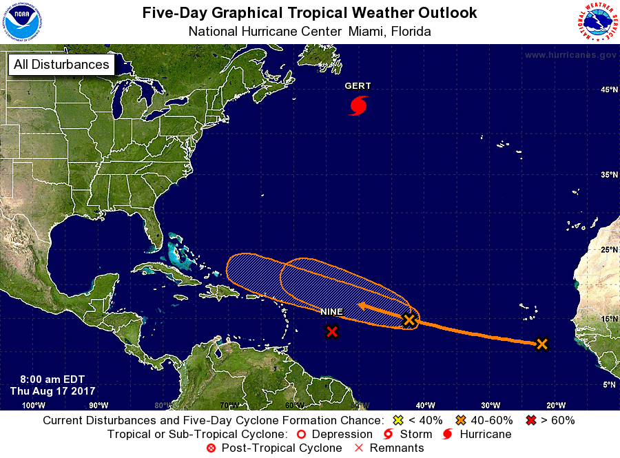
The National Hurricane Center is issuing advisories on Hurricane
Gert, located several hundred miles south of Cape Race,
Newfoundland.
1. Morning satellite imagery shows that shower activity associated
with a low pressure system centered about 550 miles east of the
Lesser Antilles has become better organized overnight, and buoy
data indicates that the circulation is becoming better defined.
Environmental conditions appear generally conducive for development,
and a tropical depression could form later today or tonight as the
system moves westward at about 15 mph. Regardless of development,
locally heavy rainfall and gusty winds are expected to spread across
portions of the Lesser Antilles and the eastern Caribbean Sea
tonight and Friday, and interests in these areas should monitor the
progress of this system. An Air Force Reserve Hurricane Hunter
aircraft is scheduled to investigate the disturbance this afternoon.
* Formation chance through 48 hours...high...80 percent.
* Formation chance through 5 days...high...90 percent.
2. Shower activity associated with a second area of low pressure
located about midway between the coast of Africa and the Lesser
Antilles has also become a little better organized during the past
24 hours. Continued gradual development of this system is possible
during the next couple of days while it moves west-northwestward at
15 to 20 mph, but upper-level winds are expected to become less
conducive for tropical cyclone formation when the disturbance moves
north of the Leeward Islands this weekend.
* Formation chance through 48 hours...medium...50 percent.
* Formation chance through 5 days...medium...60 percent.
3. A tropical wave located over the far eastern Atlantic Ocean near
the Cabo Verde Islands is producing disorganized showers and
thunderstorms. Gradual development of this system is possible
during the next several days while it moves westward to
west-northwestward at about 15 mph.
* Formation chance through 48 hours...low...near 0 percent.
* Formation chance through 5 days...medium...40 percent.
Forecaster Beven