Skip Navigation Links
NOAA NOAA United States Department of Commerce

NHC Graphical Outlook Archive


« Earliest Available         ‹ Earlier         Later ›         Latest Available »
GIS Shapefiles
tab Eastern North Pacific tab tab Atlantic tab

View 2-Day Graphical Tropical Weather Outlook
Click for Eastern North Pacific Click for Eastern North Pacific

Tropical Weather Outlook Text

ZCZC MIATWOAT ALL
TTAA00 KNHC DDHHMM

TROPICAL WEATHER OUTLOOK
NWS NATIONAL HURRICANE CENTER MIAMI FL
700 PM EST MON NOV 14 2016

For the North Atlantic...Caribbean Sea and the Gulf of Mexico:

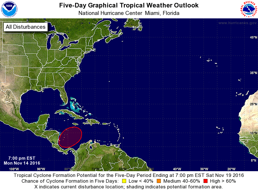
1. Cloudiness and thunderstorms have increased over the southwestern
Caribbean Sea in association with a broad area of low pressure that
is gradually forming across the region.  Environmental conditions
are conducive for slow development of this disturbance during the
next several days, and a tropical depression is likely to form by
late this week or over the weekend while the low drifts northward or
northeastward.
* Formation chance through 48 hours...low...10 percent
* Formation chance through 5 days...high...70 percent

Forecaster Kimberlain


List of Atlantic Outlooks (May 2023 - present)
List of East Pacific Outlooks (May 2023 - present)
List of Central Pacific Outlooks (May 2023 - present)
List of Atlantic Outlooks (July 2014 - April 2023)
List of East Pacific Outlooks (July 2014 - April 2023)
List of Central Pacific Outlooks (June 2019 - April 2023)
List of Atlantic Outlooks (June 2009 - June 2014)
List of East Pacific Outlooks (June 2009 - June 2014)