ZCZC MIATWOAT ALL
TTAA00 KNHC DDHHMM
TROPICAL WEATHER OUTLOOK
NWS NATIONAL HURRICANE CENTER MIAMI FL
200 PM EDT TUE SEP 13 2016
For the North Atlantic...Caribbean Sea and the Gulf of Mexico:
The National Hurricane Center is issuing advisories on Tropical
Storm Ian, located well to the east-southeast of Bermuda.
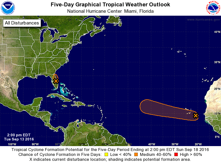
1. Surface observations, satellite images, and radar data indicate that
an area of low pressure is located just inland near Daytona Beach,
Florida. This system continues to produce a large area of showers
and thunderstorms, with winds to tropical storm force along or just
offshore of portions of the northeast Florida coast. This system is
very close to having the organization required of a tropical
cyclone, and advisories could be initiated later this afternoon.
The low is expected to move north-northwestward at 10 to 15 mph
today, near and parallel to the northeast coast of Florida.
Regardless of development, strong gusty winds will continue over
portions of the northeast Florida coast today, and heavy rains will
continue to spread over central and northern Florida today and
tonight. Please consult your local National Weather Service office
for additional information on this system, including possible
warnings.
* Formation chance through 48 hours...medium...40 percent
* Formation chance through 5 days...medium...40 percent
2. A broad area of low pressure, associated with a tropical wave,
located a couple of hundred miles east-southeast of the Cabo Verde
Islands is producing a large area of disorganized cloudiness and
showers. Slow development of this disturbance is possible during
the next several days while it moves west-northwestward at 10 to 15
mph over the tropical Atlantic. Regardless of development, locally
heavy rains and gusty winds are likely over portions of the Cabo
Verde Islands through Wednesday.
* Formation chance through 48 hours...low...30 percent
* Formation chance through 5 days...medium...50 percent
Forecaster Pasch