ZCZC MIATWOAT ALL
TTAA00 KNHC DDHHMM
TROPICAL WEATHER OUTLOOK
NWS NATIONAL HURRICANE CENTER MIAMI FL
200 AM EDT SAT AUG 27 2016
For the North Atlantic...Caribbean Sea and the Gulf of Mexico:
The National Hurricane Center is issuing advisories on Tropical
Storm Gaston, located about 900 miles east-southeast of Bermuda.
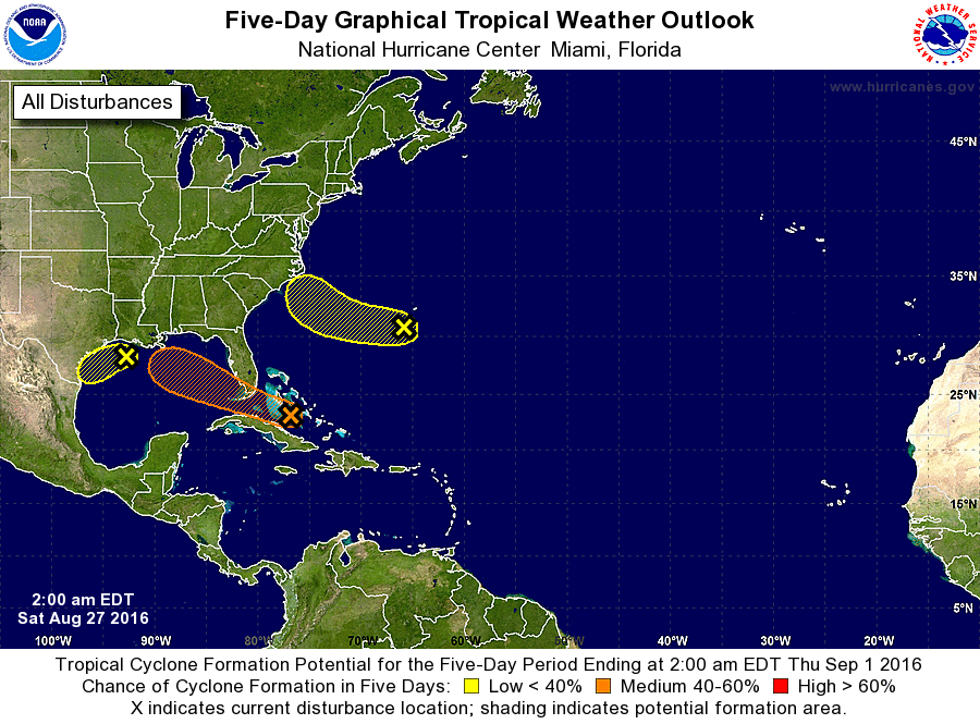
1. A weak area of low pressure located near the central Bahamas
continues to produce disorganized showers and thunderstorms mainly
to the south and east of its center. Upper-level winds are not
conducive for significant development during the next day or so
while the low moves west-northwestward through the Straits of
Florida at about 10 mph. Environmental conditions could become a
little more conducive for some development when the system moves
across the eastern Gulf of Mexico next week. Heavy rains, with the
potential to cause flash floods and mud slides, are likely to
continue over Hispaniola today. This activity is expected to spread
over eastern and central Cuba over the weekend. Gusty winds
and locally heavy rainfall are likely over portions of the Bahamas,
and will spread into parts of southern Florida and the Florida Keys
late this weekend. Interests elsewhere in Florida and the
eastern Gulf of Mexico should continue to monitor the progress of
this disturbance.
* Formation chance through 48 hours...low...20 percent
* Formation chance through 5 days...medium...40 percent
2. A weak trough of low pressure located about a hundred miles south
of the coast of southwestern Louisiana is producing disorganized
shower and thunderstorm activity over the north-central Gulf of
Mexico. Conditions are not expected to be conducive for development
of this system before it reaches the coast of Texas later this
weekend. However, heavy rainfall is possible along the Gulf Coast
from Louisiana to southeastern Texas during the next few days. For
additional information, please see products from your local National
Weather Service office.
* Formation chance through 48 hours...low...10 percent
* Formation chance through 5 days...low...10 percent
3. A broad area of low pressure is centered a little over a hundred
miles south-southwest of Bermuda. The associated shower activity
is currently disorganized. However, data from the NASA/NOAA Global
Hawk aircraft indicate that the low is producing winds near 35 mph
east of the center. This low is forecast to move westward and then
west-northwestward at about 10 mph toward the coast of the Carolinas
during the next few days, but any development is likely to be slow
to occur due to the system's proximity to dry air.
* Formation chance through 48 hours...low...20 percent
* Formation chance through 5 days...low...30 percent
Forecaster Berg