


NHC Graphical Outlook Archive
|
« Earliest Available ‹ Earlier Later › Latest Available » |
GIS Shapefiles |
| Eastern North Pacific | Atlantic |
|
Tropical Weather Outlook Text
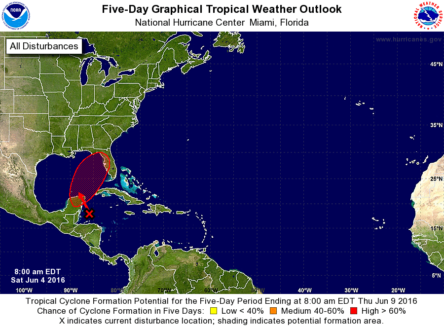
ZCZC MIATWOAT ALL
TTAA00 KNHC DDHHMM

TROPICAL WEATHER OUTLOOK
NWS NATIONAL HURRICANE CENTER MIAMI FL
800 AM EDT SAT JUN 4 2016

For the North Atlantic...Caribbean Sea and the Gulf of Mexico:

The National Hurricane Center is issuing advisories on Tropical
Storm Bonnie, located about 315 miles northwest of Bermuda.

1. Widespread cloudiness and thunderstorms over the northwestern
Caribbean Sea are currently poorly organized.  A low pressure
system is expected to form in association with this disturbed
weather over the Yucatan Peninsula of Mexico or the adjacent waters
by tomorrow and move generally northward. Subsequently, this low is
likely to develop into a tropical cyclone as it moves northeastward
across the central and eastern Gulf of Mexico early next week.
Regardless of development, locally heavy rains and flooding are
possible over portions of the Yucatan Peninsula, western Cuba, the
Florida Keys, and the Florida Peninsula during the next several
days.  Interests in these areas should monitor the progress of this
system.
* Formation chance through 48 hours...high...70 percent
* Formation chance through 5 days...high...80 percent

Forecaster Beven
List of Atlantic Outlooks (May 2023 - present)
List of East Pacific Outlooks (May 2023 - present)
List of Central Pacific Outlooks (May 2023 - present)
List of Atlantic Outlooks (July 2014 - April 2023)
List of East Pacific Outlooks (July 2014 - April 2023)
List of Central Pacific Outlooks (June 2019 - April 2023)
List of Atlantic Outlooks (June 2009 - June 2014)
List of East Pacific Outlooks (June 2009 - June 2014)