


NHC Graphical Outlook Archive
|
« Earliest Available ‹ Earlier Later › Latest Available » |
GIS Shapefiles |
| Eastern North Pacific | Atlantic |
|
Tropical Weather Outlook Text
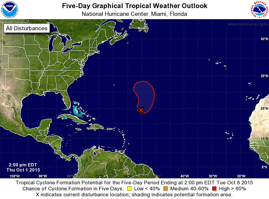
ZCZC MIATWOAT ALL
TTAA00 KNHC DDHHMM

TROPICAL WEATHER OUTLOOK
NWS NATIONAL HURRICANE CENTER MIAMI FL
200 PM EDT THU OCT 1 2015

For the North Atlantic...Caribbean Sea and the Gulf of Mexico:

The National Hurricane Center is issuing advisories on Hurricane
Joaquin, located near the central Bahamas.

1. Thunderstorms are showing some signs of organization in association
with a non-tropical area of low pressure centered over the central
Atlantic about 700 miles southeast of Bermuda.  Environmental
conditions are forecast to be conducive for the low to obtain more
tropical characteristics, and a tropical cyclone is likely to form
within a couple of days while the low moves erratically
northeastward then northward. This system is expected to produce
gale-force winds overnight and additional information on this system
can be found in High Seas Forecasts issued by the National Weather
Service.
* Formation chance through 48 hours...medium...60 percent
* Formation chance through 5 days...high...80 percent

High Seas Forecasts issued by the National Weather Service can be
found under AWIPS header NFDHSFAT1, WMO header FZNT01 KWBC, and
on the Web at http://www.opc.ncep.noaa.gov/shtml/NFDHSFAT1.shtml.

Forecaster Blake
List of Atlantic Outlooks (May 2023 - present)
List of East Pacific Outlooks (May 2023 - present)
List of Central Pacific Outlooks (May 2023 - present)
List of Atlantic Outlooks (July 2014 - April 2023)
List of East Pacific Outlooks (July 2014 - April 2023)
List of Central Pacific Outlooks (June 2019 - April 2023)
List of Atlantic Outlooks (June 2009 - June 2014)
List of East Pacific Outlooks (June 2009 - June 2014)