


NHC Graphical Outlook Archive
|
« Earliest Available ‹ Earlier Later › Latest Available » |
GIS Shapefiles |
| Eastern North Pacific | Atlantic |
|
Tropical Weather Outlook Text
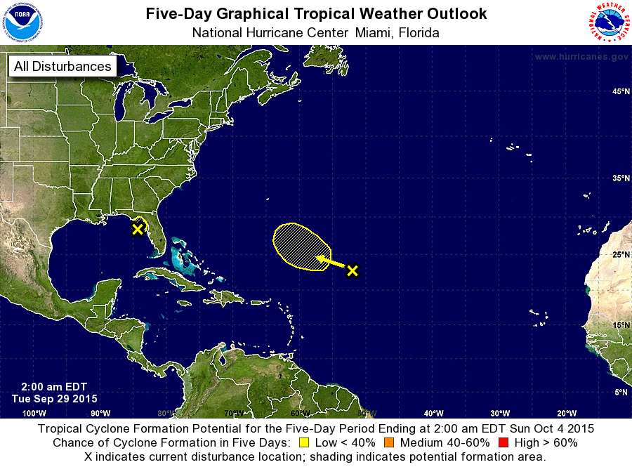
ZCZC MIATWOAT ALL
TTAA00 KNHC DDHHMM

TROPICAL WEATHER OUTLOOK
NWS NATIONAL HURRICANE CENTER MIAMI FL
200 AM EDT TUE SEP 29 2015

For the North Atlantic...Caribbean Sea and the Gulf of Mexico:

The National Hurricane Center is issuing advisories on recently
upgraded Tropical Storm Joaquin, located a few hundred miles
northeast of the central Bahamas.

1. A trough of low pressure located over the eastern Gulf of Mexico
about 100 miles west-northwest of Tampa, Florida, continues to
produce disorganized showers and thunderstorms over the northeastern
Gulf of Mexico and portions of the southeastern United States.
Strong upper-level winds will likely prevent any significant
development of this system before it moves inland over the northern
Gulf coast later today. An Air Force Reserve reconnaissance
aircraft is scheduled to investigate the disturbance later today, if
necessary. Regardless of tropical cyclone development, locally heavy
rains are likely over portions of the southeastern United States
during the next couple of days. For additional information on this
system, see High Seas Forecasts issued by the National Weather
Service and products from your local National Weather Service
office.
* Formation chance through 48 hours...low...20 percent
* Formation chance through 5 days...low...20 percent

2. A large area of disturbed weather over the central Atlantic several
hundred miles northeast of the northern Leeward Islands is
associated with a frontal trough and the remnants of Ida. Some slow
development of this system is possible later this week while it
moves slowly west-northwestward. For additional information on this
system, see High Seas Forecasts issued by the National Weather
Service.
* Formation chance through 48 hours...low...near 0 percent
* Formation chance through 5 days...low...30 percent

High Seas Forecasts issued by the National Weather Service can be
found under AWIPS header NFDHSFAT1, WMO header FZNT01 KWBC, and
on the Web at http://www.opc.ncep.noaa.gov/shtml/NFDHSFAT1.shtml.

Forecaster Brennan
List of Atlantic Outlooks (May 2023 - present)
List of East Pacific Outlooks (May 2023 - present)
List of Central Pacific Outlooks (May 2023 - present)
List of Atlantic Outlooks (July 2014 - April 2023)
List of East Pacific Outlooks (July 2014 - April 2023)
List of Central Pacific Outlooks (June 2019 - April 2023)
List of Atlantic Outlooks (June 2009 - June 2014)
List of East Pacific Outlooks (June 2009 - June 2014)