


NHC Graphical Outlook Archive
|
« Earliest Available ‹ Earlier Later › Latest Available » |
GIS Shapefiles |
| Eastern North Pacific | Atlantic |
|
Tropical Weather Outlook Text
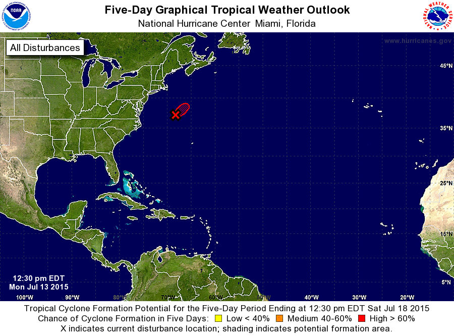
ZCZC MIATWOAT ALL
TTAA00 KNHC DDHHMM

SPECIAL TROPICAL WEATHER OUTLOOK
NWS NATIONAL HURRICANE CENTER MIAMI FL
1230 PM EDT MON JUL 13 2015

For the North Atlantic...Caribbean Sea and the Gulf of Mexico:

Special tropical weather outlook issued to update the discussion on
the low pressure system east of the United States mid-Atlantic
coast.

Satellite pictures indicate that shower and thunderstorm activity
associated with a low pressure system located about 450 miles east-
northeast of Cape Hatteras, North Carolina, continues to become
better organized.  Satellite wind data also indicate that the low's
circulation is well defined, with winds of tropical storm force.
Based on these data, advisories on a tropical storm will be issued
within the next hour. The low is expected to accelerate
northeastward during the next day or two, away from the U.S. coast.

1. * Formation chance through 48 hours...high...near 100 percent
* Formation chance through 5 days...high...near 100 percent

Forecaster Kimberlain/Brown
List of Atlantic Outlooks (May 2023 - present)
List of East Pacific Outlooks (May 2023 - present)
List of Central Pacific Outlooks (May 2023 - present)
List of Atlantic Outlooks (July 2014 - April 2023)
List of East Pacific Outlooks (July 2014 - April 2023)
List of Central Pacific Outlooks (June 2019 - April 2023)
List of Atlantic Outlooks (June 2009 - June 2014)
List of East Pacific Outlooks (June 2009 - June 2014)