


NHC Graphical Outlook Archive
|
« Earliest Available ‹ Earlier Later › Latest Available » |
| Eastern Pacific | Atlantic |
|
|
(mouse over shaded areas for details; click on shaded areas or disturbance numbers to switch views) |
Tropical Weather Outlook Text
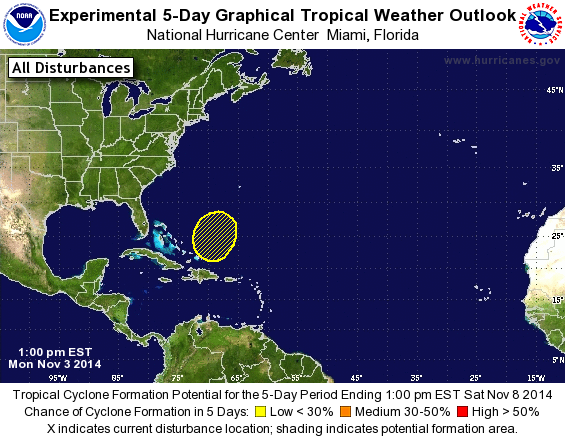
TROPICAL WEATHER OUTLOOK
NWS NATIONAL HURRICANE CENTER MIAMI FL
100 PM EST MON NOV 3 2014

For the North Atlantic...Caribbean Sea and the Gulf of Mexico:

1. An area of low pressure is expected to form to the north of
Hispaniola in a couple of days.  This system could briefly acquire
subtropical characteristics before it moves northward and
northeastward ahead of a frontal system toward the end of the week.
* Formation chance through 48 hours...low...near 0 percent.
* Formation chance through 5 days...low...10 percent.

Forecaster Cangialosi
List of Atlantic Outlooks (May 2023 - present)
List of East Pacific Outlooks (May 2023 - present)
List of Central Pacific Outlooks (May 2023 - present)
List of Atlantic Outlooks (July 2014 - April 2023)
List of East Pacific Outlooks (July 2014 - April 2023)
List of Central Pacific Outlooks (June 2019 - April 2023)
List of Atlantic Outlooks (June 2009 - June 2014)
List of East Pacific Outlooks (June 2009 - June 2014)