


NHC Graphical Outlook Archive
|
« Earliest Available ‹ Earlier Later › Latest Available » |
| Eastern Pacific | Atlantic |
|
|
(mouse over shaded areas for details; click on shaded areas or disturbance numbers to switch views) |
Tropical Weather Outlook Text
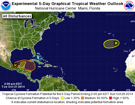
TROPICAL WEATHER OUTLOOK
NWS NATIONAL HURRICANE CENTER MIAMI FL
200 PM EDT TUE OCT 21 2014

For the North Atlantic...Caribbean Sea and the Gulf of Mexico:

1. A low pressure area in the far southern Bay of Campeche continues to
produce disorganized shower and thunderstorm activity. Upper-level
winds could become a little more conducive for development by
tomorrow, and this system still has the potential to become a
tropical cyclone before it moves inland over the west coast of the
Yucatan Peninsula late Wednesday or early Thursday.  Later in the
week, the low also has some potential for development over the
northwestern Caribbean Sea if it remains separate from a cold front.
An Air Force Reserve reconnaissance aircraft is currently
investigating the disturbance. Interests in the Yucatan Peninsula
should monitor the progress of this system.
* Formation chance through 48 hours...medium...40 percent.
* Formation chance through 5 days...medium...50 percent.

2. A large non-tropical low is located over the far eastern Atlantic
Ocean a few hundred miles south of the Azores. This system is
producing winds of gale-force and could acquire some subtropical
characteristics during the next day or so while it moves west-
southwestward at about 15 mph.  Upper-level winds are forecast to
become less conducive for subtropical or tropical cyclone formation
by Thursday and development after that time is not likely.
Additional information on this system can be found in High Seas
Forecasts issued by Meteo France.
* Formation chance through 48 hours...low...10 percent.
* Formation chance through 5 days...low...10 percent.

High Seas Forecasts issued by Meteo France can be found under WMO
header FQNT50 LFPW.

Forecaster Blake
List of Atlantic Outlooks (May 2023 - present)
List of East Pacific Outlooks (May 2023 - present)
List of Central Pacific Outlooks (May 2023 - present)
List of Atlantic Outlooks (July 2014 - April 2023)
List of East Pacific Outlooks (July 2014 - April 2023)
List of Central Pacific Outlooks (June 2019 - April 2023)
List of Atlantic Outlooks (June 2009 - June 2014)
List of East Pacific Outlooks (June 2009 - June 2014)