


NHC Graphical Outlook Archive
|
« Earliest Available ‹ Earlier Later › Latest Available » |
| Eastern Pacific | Atlantic |
|
|
(mouse over shaded areas for details; click on shaded areas or disturbance numbers to switch views) |
Tropical Weather Outlook Text
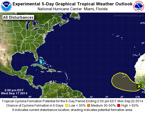
TROPICAL WEATHER OUTLOOK
NWS NATIONAL HURRICANE CENTER MIAMI FL
200 PM EDT WED SEP 17 2014

For the North Atlantic...Caribbean Sea and the Gulf of Mexico:

The National Hurricane Center is issuing advisories on Hurricane
Edouard, located several hundred miles east-northeast of Bermuda.

1. A large area of disorganized showers and thunderstorms near the west
coast of Africa is associated with a tropical wave.  Some slow
development of this system is possible over the next several days
while the disturbance moves west-northwestward or northwestward at
about 10 mph over the far eastern Atlantic Ocean.
* Formation chance through 48 hours...low...10 percent.
* Formation chance through 5 days...low...20 percent.

Forecaster Blake
List of Atlantic Outlooks (May 2023 - present)
List of East Pacific Outlooks (May 2023 - present)
List of Central Pacific Outlooks (May 2023 - present)
List of Atlantic Outlooks (July 2014 - April 2023)
List of East Pacific Outlooks (July 2014 - April 2023)
List of Central Pacific Outlooks (June 2019 - April 2023)
List of Atlantic Outlooks (June 2009 - June 2014)
List of East Pacific Outlooks (June 2009 - June 2014)