


NHC Graphical Outlook Archive
|
« Earliest Available ‹ Earlier Later › Latest Available » |
| Eastern Pacific | Atlantic |
|
|
(mouse over shaded areas for details; click on shaded areas or disturbance numbers to switch views) |
Tropical Weather Outlook Text
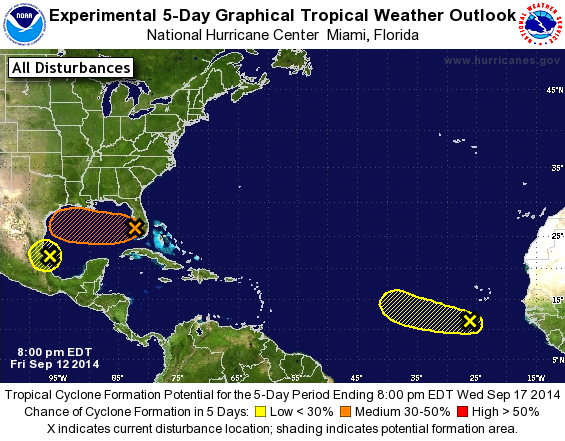
TROPICAL WEATHER OUTLOOK
NWS NATIONAL HURRICANE CENTER MIAMI FL
800 PM EDT FRI SEP 12 2014

For the North Atlantic...Caribbean Sea and the Gulf of Mexico:

The National Hurricane Center is issuing advisories on Tropical
Storm Edouard, located about 1200 miles east-northeast of the
northern Leeward Islands.

1. Shower activity associated with the broad area of low pressure
centered over the southeastern Gulf of Mexico west of Fort Myers
Florida remains poorly organized.  Upper-level winds appear
unfavorable for significant development as the system moves
generally westward during the next few days.  Nevertheless, this
system will continue to be closely monitored, and an Air Force
Reserve Hurricane Hunter aircraft is scheduled to investigate the
low on Saturday, if necessary. Locally heavy rains associated with
the low will continue over portions of southern Florida and the
Florida Keys tonight and Saturday.
* Formation chance through 48 hours...low...20 percent.
* Formation chance through 5 days...medium...30 percent.

2. Shower activity associated with a tropical wave located south of
the Cape Verde Islands continues to show signs of organization. This
system, however, is forecast to move westward or west-northwestward
at around 10 mph toward an area unfavorable for development.
* Formation chance through 48 hours...low...20 percent.
* Formation chance through 5 days...low...20 percent.

3. Shower activity has increased this afternoon in association with a
tropical wave over the southwestern Gulf of Mexico.  Surface
observations indicate that pressures are low in this area, and some
additional development could occur before the system moves into
eastern Mexico later tonight or on Saturday.  Regardless of
development, locally heavy rains and gusty winds are likely to
spread over portions of eastern Mexico tonight and Saturday.
* Formation chance through 48 hours...low...10 percent.
* Formation chance through 5 days...low...10 percent.

Forecaster Beven
List of Atlantic Outlooks (May 2023 - present)
List of East Pacific Outlooks (May 2023 - present)
List of Central Pacific Outlooks (May 2023 - present)
List of Atlantic Outlooks (July 2014 - April 2023)
List of East Pacific Outlooks (July 2014 - April 2023)
List of Central Pacific Outlooks (June 2019 - April 2023)
List of Atlantic Outlooks (June 2009 - June 2014)
List of East Pacific Outlooks (June 2009 - June 2014)