


NHC Graphical Outlook Archive
|
« Earliest Available ‹ Earlier Later › Latest Available » |
| Eastern Pacific | Atlantic |
|
|
(mouse over shaded areas for details; click on shaded areas or disturbance numbers to switch views) |
Tropical Weather Outlook Text
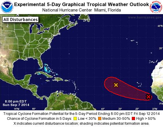
TROPICAL WEATHER OUTLOOK
NWS NATIONAL HURRICANE CENTER MIAMI FL
800 PM EDT SUN SEP 7 2014

For the North Atlantic...Caribbean Sea and the Gulf of Mexico:

1. A tropical wave is producing a large area of cloudiness and
disorganized thunderstorms over the far eastern Atlantic just off
the west coast of Africa.  Environmental conditions are expected to
be conducive for gradual development of this disturbance during the
next several days while it moves westward or west-northwestward at
about 15 mph.
* Formation chance through 48 hours...medium...30 percent.
* Formation chance through 5 days...high...60 percent.

2. A weak area of low pressure located almost 800 miles west of the
Cape Verde Islands is producing limited shower activity.
Environmental conditions are not conducive for development, and
tropical cyclone formation is not expected while the system moves
westward to west-northwestward at 15 to 20 mph during the next
several days.
* Formation chance through 48 hours...low...near 0 percent.
* Formation chance through 5 days...low...near 0 percent.

Forecaster Berg
List of Atlantic Outlooks (May 2023 - present)
List of East Pacific Outlooks (May 2023 - present)
List of Central Pacific Outlooks (May 2023 - present)
List of Atlantic Outlooks (July 2014 - April 2023)
List of East Pacific Outlooks (July 2014 - April 2023)
List of Central Pacific Outlooks (June 2019 - April 2023)
List of Atlantic Outlooks (June 2009 - June 2014)
List of East Pacific Outlooks (June 2009 - June 2014)