


NHC Graphical Outlook Archive
|
« Earliest Available ‹ Earlier Later › Latest Available » |
| Eastern Pacific | Atlantic |
|
|
(mouse over shaded areas for details; click on shaded areas or disturbance numbers to switch views) |
Tropical Weather Outlook Text
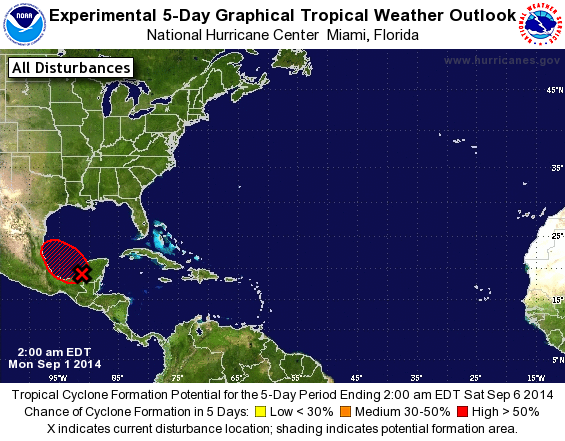
TROPICAL WEATHER OUTLOOK
NWS NATIONAL HURRICANE CENTER MIAMI FL
200 AM EDT MON SEP 1 2014

For the North Atlantic...Caribbean Sea and the Gulf of Mexico:

1. A broad area of low pressure located south of Campeche on the
western coast of the Yucatan Peninsula is producing a large area of
showers and scattered thunderstorms. This system is showing signs of
organization while it moves west-northwestward at about 10 mph, and
development of a tropical depression will be possible when the
center of the disturbance moves over the warm waters of the Bay of
Campeche later today and into Tuesday.  An Air Force Reserve
reconnaissance aircraft is scheduled to investigate the low this
afternoon, if necessary. Regardless of development, this system will
produce heavy rainfall across the Yucatan Peninsula and southeastern
Mexico today and Tuesday, and across portions of eastern mainland
Mexico on Tuesday and Wednesday.
* Formation chance through 48 hours...high...60 percent.
* Formation chance through 5 days...high...70 percent.

Forecaster Stewart
List of Atlantic Outlooks (May 2023 - present)
List of East Pacific Outlooks (May 2023 - present)
List of Central Pacific Outlooks (May 2023 - present)
List of Atlantic Outlooks (July 2014 - April 2023)
List of East Pacific Outlooks (July 2014 - April 2023)
List of Central Pacific Outlooks (June 2019 - April 2023)
List of Atlantic Outlooks (June 2009 - June 2014)
List of East Pacific Outlooks (June 2009 - June 2014)