ZCZC MIATWOEP ALL
TTAA00 KNHC DDHHMM
Tropical Weather Outlook
NWS National Hurricane Center Miami FL
1100 PM PDT Fri Oct 27 2023
For the eastern North Pacific...east of 140 degrees west longitude:
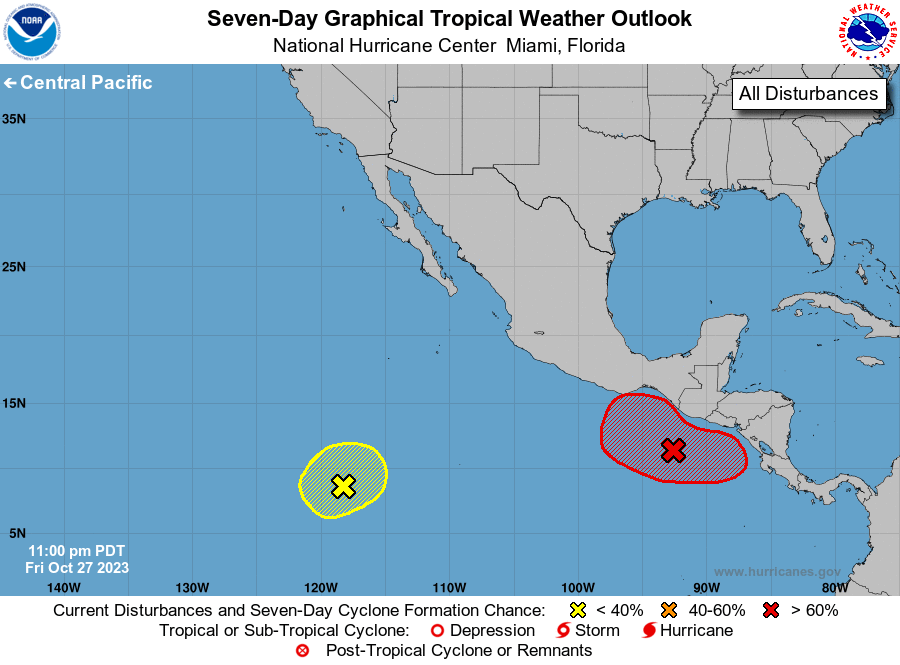
1. South of Central America and Mexico (EP92):
A broad area of low pressure located a couple of hundred miles south
of the coast of Guatemala is producing disorganized shower and
thunderstorm activity. Environmental conditions are expected to be
conducive for development during the next few days, and a tropical
depression is likely to form this weekend or early next week.
Regardless of development, the low is forecast to meander over the
far eastern portion of the Eastern Pacific basin for the next
several days. For additional information, including gale warnings,
see High Seas Forecasts issued by the National Weather Service.
* Formation chance through 48 hours...high...80 percent.
* Formation chance through 7 days...high...90 percent.
2. Southwestern East Pacific:
A weak area of low pressure located well to the south-southwest of
the southern tip of the Baja California peninsula is producing
limited and disorganized shower activity. Environmental conditions
are forecast to be marginally conducive for slow development of the
low through early next week while it drifts slowly northeastward.
* Formation chance through 48 hours...low...near 0 percent.
* Formation chance through 7 days...low...20 percent.
High Seas Forecasts issued by the National Weather Service
can be found under AWIPS header NFDHSFEPI, WMO header FZPN02
KWBC, and on the web at ocean.weather.gov/shtml/NFDHSFEPI.php
Forecaster Kelly