ZCZC MIATWOEP ALL
TTAA00 KNHC DDHHMM AAA
Tropical Weather Outlook...Updated
NWS National Hurricane Center Miami FL
1100 AM PDT Mon Oct 16 2023
Updated to include gale warnings and High Seas forecast information
for EP90.
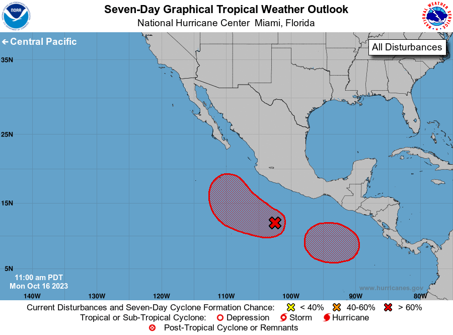
For the eastern North Pacific...east of 140 degrees west longitude:
1. South of Southwestern Mexico (EP90):
An area of low pressure located a few hundred miles offshore of the
southwestern coast of Mexico is producing showers and thunderstorms
that have become better organized since yesterday. Environmental
conditions are conducive for further development of this system, and
a tropical depression is very likely to form within the next day or
so. This system is expected to move slowly westward and then turn
northwestward late in the week offshore of the coast of southwestern
Mexico. Additional information on this system, including gale
warnings, can be found in High Seas Forecasts issued by the National
Weather Service.
* Formation chance through 48 hours...high...90 percent.
* Formation chance through 7 days...high...90 percent.
2. South of Guatemala and Southern Mexico:
An area of low pressure is expected to form south of the coasts of
Guatemala and southern Mexico in a few days. Gradual development of
the disturbance will be possible, and a tropical depression is
likely to form late this week or over the weekend while the system
meanders over the far eastern portion of the basin.
* Formation chance through 48 hours...low...near 0 percent.
* Formation chance through 7 days...high...70 percent.
High Seas Forecasts issued by the National Weather Service
can be found under AWIPS header NFDHSFEPI, WMO header FZPN02
KWBC, and on the web at ocean.weather.gov/shtml/NFDHSFEPI.php
Forecaster Kelly