ZCZC MIATWOAT ALL
TTAA00 KNHC DDHHMM
Tropical Weather Outlook
NWS National Hurricane Center Miami FL
200 PM EDT Mon Sep 4 2023
For the North Atlantic...Caribbean Sea and the Gulf of Mexico:
Active Systems:
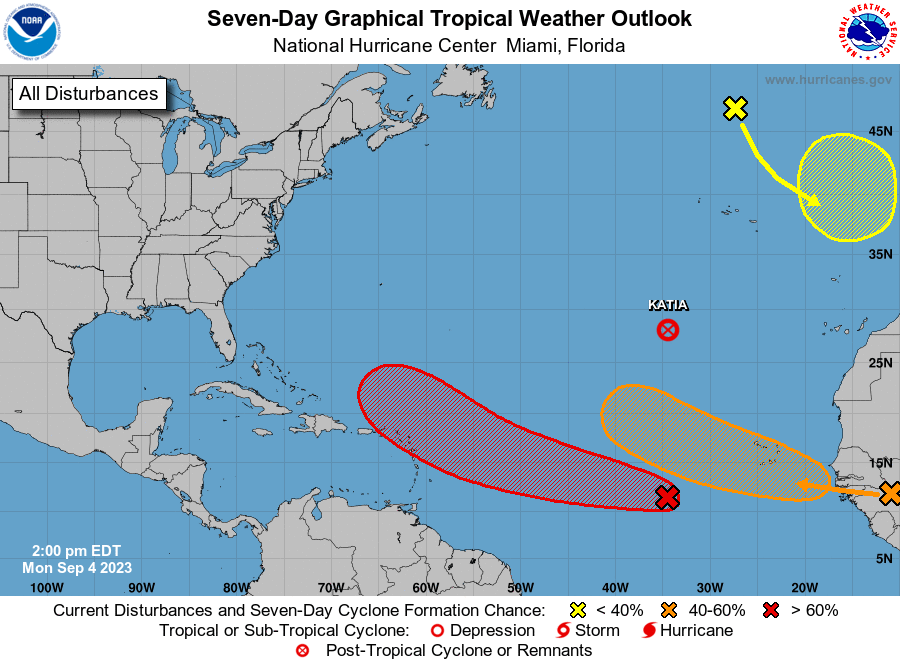
The National Hurricane Center is issuing advisories on Tropical
Depression Katia, located over the eastern subtropical
Atlantic, and has issued the last advisory on the remnants of Gert,
located over the central subtropical Atlantic.
1. Central Tropical Atlantic (AL95):
Satellite imagery indicates that an area of low pressure has formed
from the tropical wave centered about 700 miles west-southwest of
the Cabo Verde Islands. The low-level circulation has become better
defined since yesterday, with increasing organization in the shower
and thunderstorm activity. Environmental conditions are forecast to
be conducive for further development, and this system is expected to
become a tropical depression or a tropical storm in a day or two.
Additional strengthening is likely late this week while the system
moves westward to west-northwestward at 15 to 20 mph over the
central and western portions of the tropical Atlantic. For
additional information on this system, including gale warnings, see
High Seas Forecasts issued by the National Weather Service.
* Formation chance through 48 hours...high...90 percent.
* Formation chance through 7 days...high...near 100 percent.
2. Eastern Tropical Atlantic:
A strong tropical wave over western Africa is forecast to move off
the African coast in a couple of days. Environmental conditions
should support some slow development, and a tropical depression
could form over the far eastern tropical Atlantic around the latter
part of the week or the weekend while the wave moves to the
west-northwest at about 15 mph.
* Formation chance through 48 hours...low...near 0 percent.
* Formation chance through 7 days...medium...50 percent.
3. Northeastern Atlantic (ex-Franklin):
Post-Tropical Cyclone Franklin is located several hundred miles
north of the Azores and is forecast to move quickly southeastward
towards warmer waters east of Azores. This system could acquire some
subtropical or tropical characteristics late this week or this
weekend while it moves erratically between the Azores and Portugal.
For additional information on this system, including gale warnings,
see High Seas Forecasts issued by Meteo France.
* Formation chance through 48 hours...low...near 0 percent.
* Formation chance through 7 days...low...20 percent.
High Seas Forecasts issued by the National Weather Service can be
found under AWIPS header NFDHSFAT1, WMO header FZNT01 KWBC, and
online at ocean.weather.gov/shtml/NFDHSFAT1.php
Additional information on Post-Tropical Cyclone Franklin
can be found in High Seas Forecasts issued by Meteo France under
WMO header FQNT50 LFPW and online at
www.meteofrance.com/previsions-meteo-marine/bulletin/grandlarge/
metarea2
Forecaster Blake