ZCZC MIATWOAT ALL
TTAA00 KNHC DDHHMM
Tropical Weather Outlook
NWS National Hurricane Center Miami FL
200 PM EDT Thu Aug 24 2023
For the North Atlantic...Caribbean Sea and the Gulf of Mexico:
Active Systems:
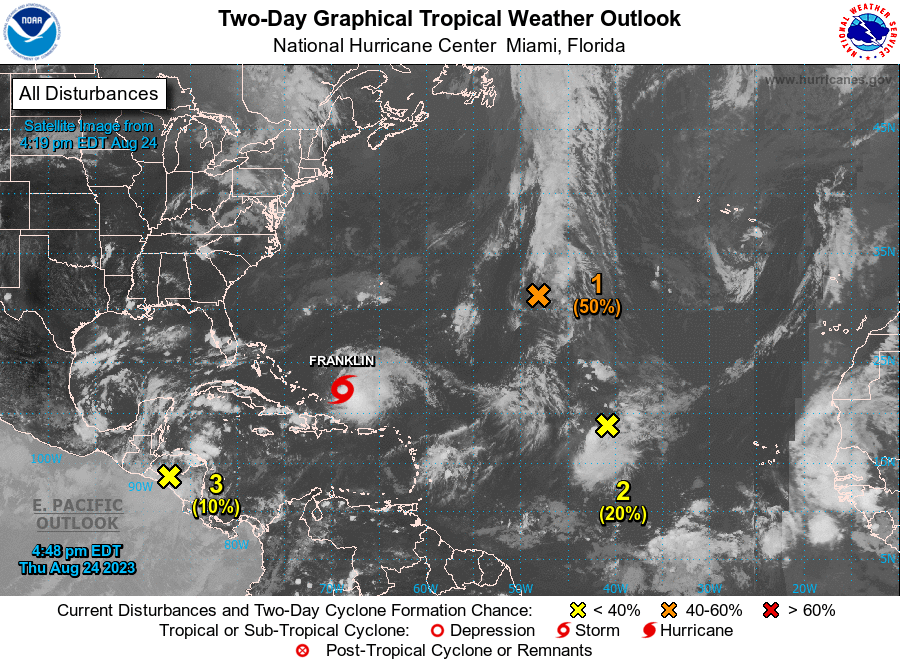
The National Hurricane Center is issuing advisories on Tropical
Storm Franklin, located to the east of the Turks and Caicos
Islands.
1. Central Subtropical Atlantic (Remnants of Emily):
A trough of low pressure located more than 1000 miles east-southeast
of Bermuda (the remnants of former Tropical Storm Emily) is
producing an elongated area of disorganized showers and
thunderstorms. Recently received satellite wind data suggests that
the system has lost organization from yesterday, but a tropical
depression or storm could still form as it moves northward over the
subtropical central Atlantic. By this weekend, the system is
expected to merge with a frontal boundary north of the Gulf
Stream. For additional information on this system, including gale
warnings, see High Seas Forecasts issued by the National Weather
Service.
* Formation chance through 48 hours...medium...50 percent.
* Formation chance through 7 days...medium...50 percent.
2. Central Tropical Atlantic (AL92):
Disorganized showers and thunderstorms continue in association with
an area of low pressure located midway between the Cabo Verde
Islands and the northern Lesser Antilles. While environmental
conditions are marginal for additional development, they could
become more conducive in a few days. A tropical depression could
form by early next week while the system moves west-northwestward to
northwestward into the central subtropical Atlantic.
* Formation chance through 48 hours...low...20 percent.
* Formation chance through 7 days...medium...50 percent.
3. Northwestern Caribbean Sea:
A broad area of low pressure centered over Central America is
forecast to move into northwestern Caribbean Sea by this weekend.
Some gradual development of this system is possible thereafter into
early next week, and a tropical depression could form while it moves
slowly northward, entering the eastern Gulf of Mexico.
* Formation chance through 48 hours...low...10 percent.
* Formation chance through 7 days...medium...60 percent.
High Seas Forecasts issued by the National Weather Service can be
found under AWIPS header NFDHSFAT1, WMO header FZNT01 KWBC, and
online at ocean.weather.gov/shtml/NFDHSFAT1.php
Forecaster Papin/Delgado