ZCZC MIATWOAT ALL
TTAA00 KNHC DDHHMM
Tropical Weather Outlook
NWS National Hurricane Center Miami FL
800 PM EDT Wed Aug 23 2023
For the North Atlantic...Caribbean Sea and the Gulf of Mexico:
Active Systems:
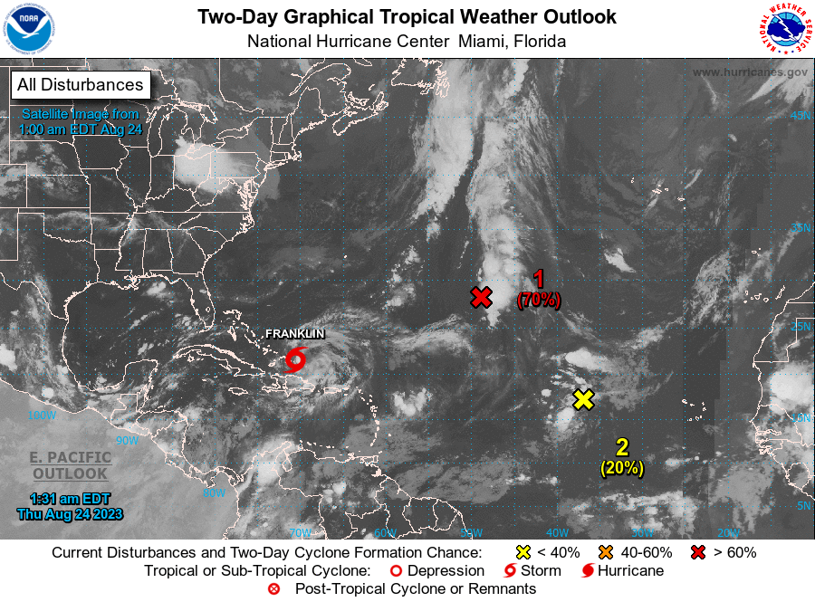
The National Hurricane Center is issuing advisories on Tropical
Storm Franklin, located just north of the Dominican Republic.
1. Central Subtropical Atlantic (Remnants of Emily):
An area of low pressure located about 1000 miles east-southeast of
Bermuda (the remnants of former Tropical Storm Emily) continues to
produce a large area of disorganized showers and thunderstorms.
Upper-level winds are forecast to become more conducive for
development by tomorrow, and this system is likely to regenerate
into a tropical storm by Friday while the system moves northward
over the subtropical central Atlantic. For additional information
on this system, including gale warnings, see High Seas Forecasts
issued by the National Weather Service.
* Formation chance through 48 hours...high...70 percent.
* Formation chance through 7 days...high...70 percent.
2. Eastern Tropical Atlantic (AL92):
Disorganized showers and thunderstorms continue in association with
an area of low pressure located several hundred miles west of the
Cabo Verde Islands. This system's circulation has become better
defined since yesterday, despite marginal environmental conditions,
and further slow development is possible. The low has the potential
to become a tropical depression by the weekend while the system
moves west-northwestward to northwestward into the central tropical
Atlantic.
* Formation chance through 48 hours...low...20 percent.
* Formation chance through 7 days...medium...40 percent.
3. Northwestern Caribbean Sea:
An area of low pressure could form in a couple of days over the
northwestern Caribbean Sea. Some slow development of this system
is possible over the weekend and early next week while it moves
slowly northward across the eastern Gulf of Mexico.
* Formation chance through 48 hours...low...near 0 percent.
* Formation chance through 7 days...low...20 percent.
High Seas Forecasts issued by the National Weather Service can be
found under AWIPS header NFDHSFAT1, WMO header FZNT01 KWBC, and
online at ocean.weather.gov/shtml/NFDHSFAT1.php
Forecaster Blake