ZCZC MIATWOAT ALL
TTAA00 KNHC DDHHMM
Special Tropical Weather Outlook
NWS National Hurricane Center Miami FL
335 PM EDT Sat Aug 19 2023
For the North Atlantic...Caribbean Sea and the Gulf of Mexico:
Special outlook issued to update the discussion of the disturbance
in the Central Tropical Atlantic (AL99).
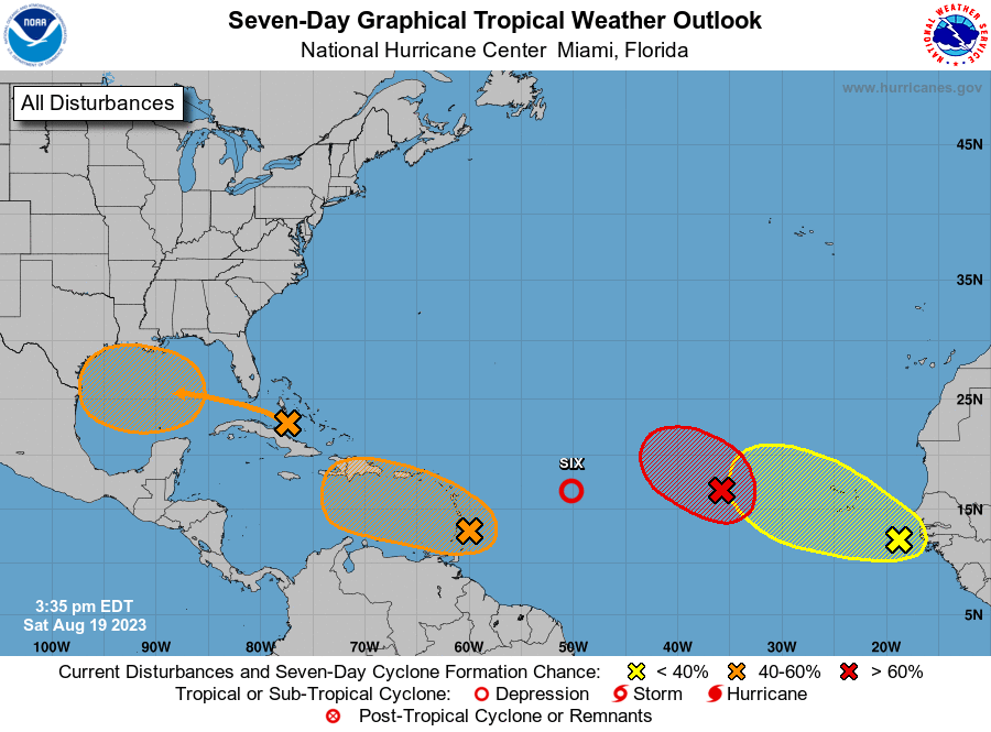
1. Eastern Tropical Atlantic (AL98):
Shower and thunderstorm activity continues in association with a
broad area of low pressure located several hundred miles west of the
Cabo Verde Islands. Environmental conditions appear generally
favorable for further development of this system, and a short-lived
tropical depression is likely to form this weekend while it moves
west-northwestward or northwestward at about 10 mph across the
eastern tropical Atlantic. By early next week, upper-level winds
over the system are forecast to increase, and further development is
not expected.
* Formation chance through 48 hours...high...70 percent.
* Formation chance through 7 days...high...70 percent.
2. Central Tropical Atlantic (AL99):
Updated: Showers and thunderstorms associated with an area of low
pressure located roughly halfway between the Cabo Verde Islands and
the Lesser Antilles have persisted and become better organized
this afternoon. If these development trends continue, a
short-lived tropical depression is likely to form this afternoon or
evening, while the system moves west-northwestward at 10 to 15 mph
across the tropical Atlantic. Upper-level winds are expected to
become increasingly unfavorable by late this weekend, with any
further development not anticipated.
* Formation chance through 48 hours...high...70 percent.
* Formation chance through 7 days...high...70 percent.
3. Near the Windward Islands (AL90):
A broad area of low pressure has formed near the Windward Islands,
shower and thunderstorm activity has become better organized since
yesterday. Some additional development of this system is likely and
a tropical depression could form by early next week while this
system moves westward to west-northwestward at 10 to 15 mph, across
the Lesser Antilles and over the eastern and central Caribbean Sea.
Regardless of development, heavy rainfall is possible over portions
of the Windward Islands during the next couple of days. Interests
in the eastern and central Caribbean should monitor the progress of
this system.
* Formation chance through 48 hours...medium...40 percent.
* Formation chance through 7 days...medium...60 percent.
4. Western Gulf of Mexico:
An area of disturbed weather located near the northwestern and
central Bahamas is expected to move into the Gulf of Mexico by early
next week, where a broad area of low pressure is expected to form.
Some slow development of this system is possible thereafter, and a
tropical depression could form as it moves westward and approaches
the western Gulf of Mexico coastline by the middle of next week.
* Formation chance through 48 hours...low...10 percent.
* Formation chance through 7 days...medium...50 percent.
5. Near the coast of Africa:
A tropical wave located near the western coast of Africa is
producing a large area of disorganized showers and thunderstorms.
Some slow development is possible while it moves generally
west-northwestward across the tropical eastern Atlantic during the
next several days.
* Formation chance through 48 hours...low...near 0 percent.
* Formation chance through 7 days...low...20 percent.
Forecaster Kelly/Brown