ZCZC MIATWOEP ALL
TTAA00 KNHC DDHHMM
Tropical Weather Outlook
NWS National Hurricane Center Miami FL
1100 PM PDT Tue Aug 15 2023
For the eastern North Pacific...east of 140 degrees west longitude:
Active Systems:
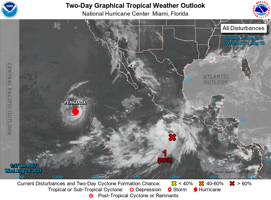
The National Hurricane Center is issuing advisories on Hurricane
Fernanda, located about 1000 miles west-southwest of the
southern tip of the Baja California peninsula.
1. Off the Coast of Southwestern Mexico (EP90):
Showers and thunderstorms are continuing to show signs of
organization in association with a broad area of low pressure
located a few hundred miles south of Acapulco, Mexico.
Environmental conditions appear conducive for continued
development, and a tropical depression or tropical storm is
anticipated to form within the next day or so. The system is
expected to move west-northwestward to northwestward, roughly
parallel to the coast of southwestern Mexico and the Baja California
peninsula during the next several days. Additional information on
this system, including gale warnings, can be found in High Seas
Forecasts issued by the National Weather Service.
* Formation chance through 48 hours...high...90 percent.
* Formation chance through 7 days...high...90 percent.
2. South of Central America and Southern Mexico:
An area of low pressure could form south of the Gulf of Tehuantepec
over the weekend. Some gradual development of this system is
possible thereafter while it moves generally west-northwestward.
* Formation chance through 48 hours...low...near 0 percent.
* Formation chance through 7 days...low...20 percent.
High Seas Forecasts issued by the National Weather Service
can be found under AWIPS header NFDHSFEPI, WMO header FZPN02
KWBC, and on the web at ocean.weather.gov/shtml/NFDHSFEPI.php
Forecaster Kelly/Berg