ZCZC MIATWOEP ALL
TTAA00 KNHC DDHHMM
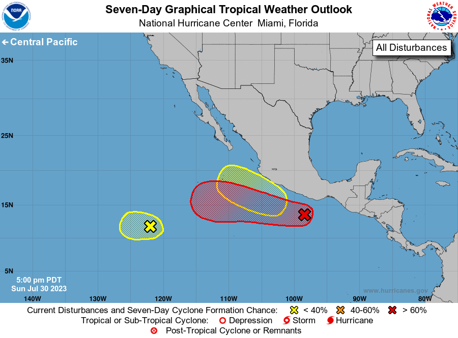
Tropical Weather Outlook
NWS National Hurricane Center Miami FL
500 PM PDT Sun Jul 30 2023
For the eastern North Pacific...east of 140 degrees west longitude:
1. Offshore of Southern Mexico (EP96):
Showers and thunderstorms continue to show signs of organization in
association with an area of low pressure located to the south of the
southern coast of Mexico. Although recent satellite wind data
indicate that the system does not have a well-defined center,
environmental conditions seem favorable for further development,
and a tropical depression is likely to form within a day or two
while the system moves westward near 15 mph.
* Formation chance through 48 hours...high...70 percent.
* Formation chance through 7 days...high...90 percent.
2. Southwest of southern Baja California:
A small area of low pressure located about 1100 miles southwest of
the southern tip of Baja California is still producing a few
showers and thunderstorms. Significant development of this system
is unlikely due to strong upper-level winds while it moves westward
at 10 to 15 mph during the next couple of days.
* Formation chance through 48 hours...low...10 percent.
* Formation chance through 7 days...low...10 percent.
3. South of Southwestern Mexico:
An area of low pressure could form late this week a few hundred
miles south of the coast of southwestern Mexico. Some gradual
development is possible by the upcoming weekend while the system
moves west-northwestward or northwestward, roughly parallel to the
southwestern coast of Mexico.
* Formation chance through 48 hours...low...near 0 percent.
* Formation chance through 7 days...low...20 percent.
Forecaster Blake