ZCZC MIATWOAT ALL
TTAA00 KNHC DDHHMM

Tropical Weather Outlook
NWS National Hurricane Center Miami FL
200 PM EDT Mon Jul 24 2023

For the North Atlantic...Caribbean Sea and the Gulf of Mexico:

Active Systems:
The National Hurricane Center has issued the last advisory on
Post-Tropical Cyclone Don, located over the north-central Atlantic.

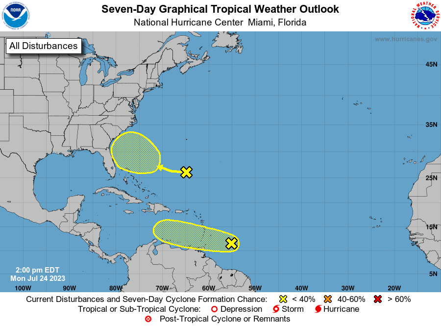
1. East of the Windward Islands (AL95):
A tropical wave is located a few hundred miles east of the Windward
Islands.  Although this system has not become any better organized
since yesterday, some slow development remains possible during the
next couple of days while it moves westward near 20 mph across the
tropical Atlantic and into the eastern Caribbean Sea.  Regardless of
development, locally heavy rains and strong gusty winds are possible
across portions of the Lesser Antilles during the next day or two.
Environmental conditions are expected to become unfavorable for
development of this system by the middle of the week.
* Formation chance through 48 hours...low...20 percent.
* Formation chance through 7 days...low...20 percent.

2. Southwestern Western Atlantic:
A weak trough of low pressure is located a few hundred miles south
of Bermuda.  Environmental conditions are expected to become
marginally conducive for some gradual development of this system as
it moves towards the southeastern U.S. coast later this week and
into the weekend.
* Formation chance through 48 hours...low...near 0 percent.
* Formation chance through 7 days...low...20 percent.

Forecaster Pasch/Kelly





 NHC on Facebook
 Twitter
 YouTube
 NHC Blog: