ZCZC MIATWOEP ALL
TTAA00 KNHC DDHHMM
Tropical Weather Outlook
NWS National Hurricane Center Miami FL
1100 AM PDT Sat Jul 8 2023
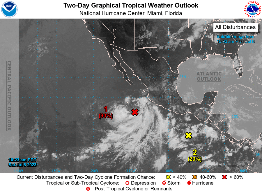
For the eastern North Pacific...east of 140 degrees west longitude:
1. Offshore of Southwestern Mexico (EP93):
Showers and thunderstorms continue to gradually become better
organized in association with a large area of low pressure located a
few hundred miles southwest of Manzanillo, Mexico. If this trend
continues, advisories will likely be initiated on this system later
today or tonight. The low is expected to move generally
west-northwestward, away from the coast of mainland Mexico during
the next few days. Additional information on this system, including
gale warnings, can be found in High Seas Forecasts issued by the
National Weather Service.
* Formation chance through 48 hours...high...90 percent.
* Formation chance through 7 days...high...90 percent.
2. Offshore of Southern Mexico:
A trough of low pressure a few hundred miles south of southern
Mexico is producing disorganized showers and thunderstorms.
Environmental conditions are expected to be conducive for gradual
development during the next several days, and a tropical depression
is likely to form during the early to middle portions of next week.
The system is expected to move westward to west-northwestward
parallel to, but well offshore of the coast of southern and
southwestern Mexico.
* Formation chance through 48 hours...low...20 percent.
* Formation chance through 7 days...high...80 percent.
High Seas Forecasts issued by the National Weather Service
can be found under AWIPS header NFDHSFEPI, WMO header FZPN02
KWBC, and on the web at ocean.weather.gov/shtml/NFDHSFEPI.php
Forecaster Cangialosi