ZCZC MIATWOEP ALL
TTAA00 KNHC DDHHMM
Tropical Weather Outlook
NWS National Hurricane Center Miami FL
500 AM PDT Fri Jul 7 2023
For the eastern North Pacific...east of 140 degrees west longitude:
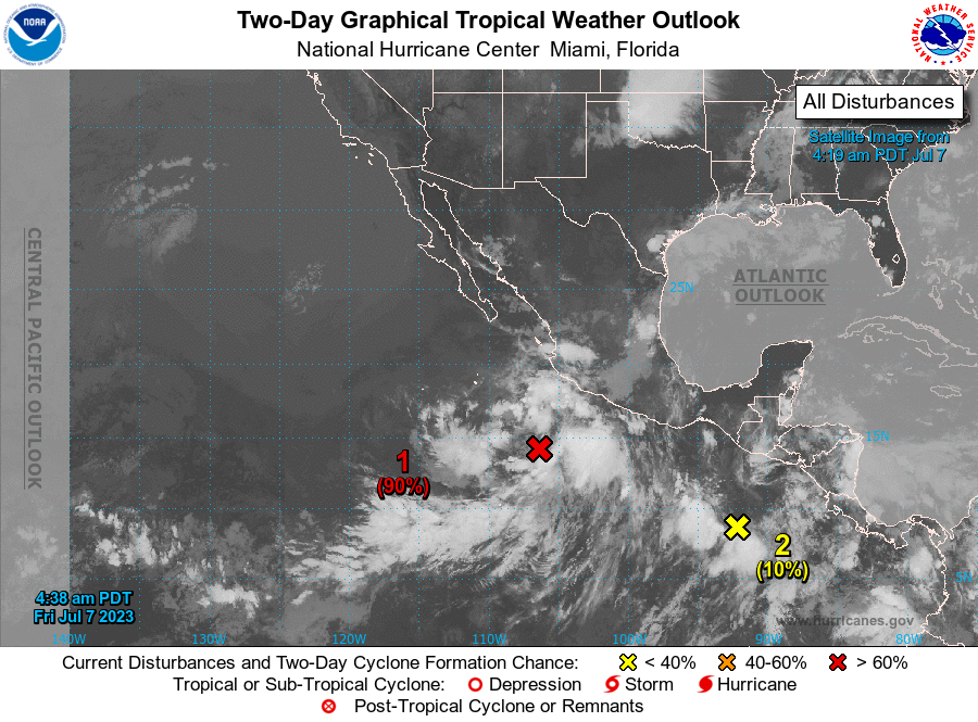
1. Offshore of Southwestern Mexico (EP93):
Showers and thunderstorms associated with a broad area of low
pressure located several hundred miles south-southwest of
Manzanillo, Mexico, are showing some signs of organization.
Environmental conditions are forecast to remain conducive
for additional development, and a tropical depression is likely to
form within the next day or so while the disturbance moves
generally west-northwestward, away from the coast of mainland
Mexico.
* Formation chance through 48 hours...high...90 percent.
* Formation chance through 7 days...high...90 percent.
2. Offshore of Southern Mexico:
An elongated trough of low pressure located well south-southeast
of southeastern Mexico is producing disorganized showers and
thunderstorms. Environmental conditions are expected to be
conducive for gradual development of this system during the next
several days, and a tropical depression is likely to form early next
week. The system is forecast to move westward to west-northwestward
parallel to, but well offshore, of the coast of southern Mexico.
* Formation chance through 48 hours...low...10 percent.
* Formation chance through 7 days...high...70 percent.
Forecaster Brown