


NHC Graphical Outlook Archive
« Earliest Available ‹ Earlier Later › Latest Available »
Place your mouse cursor over areas of interest for more information
| GIS data: .shp |
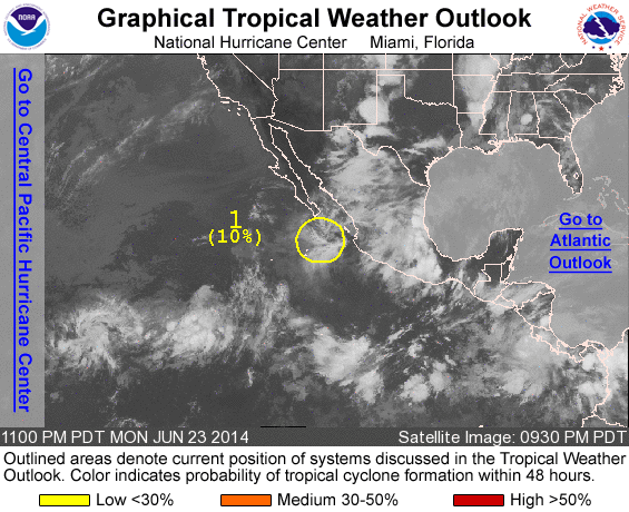
ZCZC MIATWOEP ALL
TTAA00 KNHC DDHHMM

TROPICAL WEATHER OUTLOOK
NWS NATIONAL HURRICANE CENTER MIAMI FL
1100 PM PDT MON JUN 23 2014

For the eastern North Pacific...east of 140 degrees west longitude:

1. A weak area of low pressure located a couple of hundred miles south
of the southern tip of the Baja California peninsula is producing
disoranized cloudiness and showers.  Development of this system is
not expected while it moves little during the next day or two.
* Formation chance through 48 hours...low...10 percent.
* Formation chance through 5 days...low...10 percent.

2. A low pressure system is expected to form to the south of Mexico
late this week, and development of this system is possible by the
weekend while it moves west-northwestward.
* Formation chance through 48 hours...low...near 0 percent.
* Formation chance through 5 days...medium...30 percent.

Forecaster Cangialosi
List of all Atlantic Outlooks
List of all East Pacific Outlooks