NHC Offshore Waters Forecasts
Hover to view popup zone forecast; click a zone to view related text forecast below. Show All Text Below
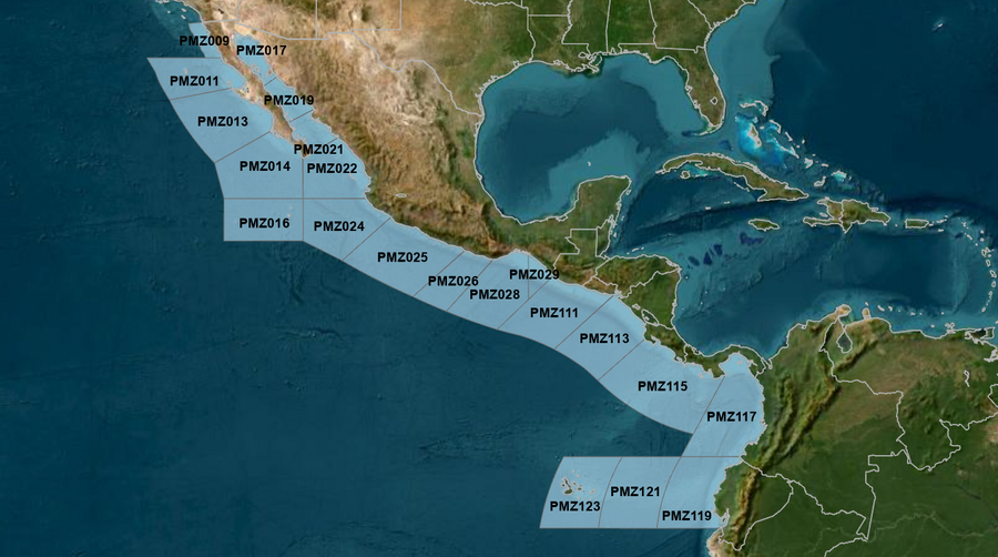
East Pacific within 250 nm of Mexico (OFFPZ7)
000
FZPN27 KNHC 212130
OFFPZ7

Offshore Waters Forecast
NWS National Hurricane Center Miami, FL
230 PM PDT Tue Jul 21 2026

Offshore Waters Forecast for the E Pacific within 250 nm of
Mexico

Seas given as significant wave height, which is the average
height of the highest 1/3 of the waves. Individual waves may be
more than twice the significant wave height.
Synopsis for the E Pacific within 250 nm of Mexico
PMZ001-220930-
Synopsis for the E Pacific within 250 nm of Mexico
230 PM PDT Tue Jul 21 2026

.SYNOPSIS...Hurricane Fausto is centered near 16.6N 119.9W at
21/2100 UTC, moving west-northwest at 10 kt. Estimated minimum
central pressure is 987 mb. Maximum sustained wind speed is 65 kt
with gusts to 80 kt. Peak seas are near 28 ft. Fausto will move
to 17.0N 121.1W Wed morning, 17.4N 122.7W Wed afternoon, 17.7N
124.6W Thu morning, 17.9N 127.0W Thu afternoon, 18.3N 129.6W Fri
morning, and 18.6N 132.3W Fri afternoon. Fausto will change
little in intensity as it moves to near 19.4N 137.4W Sat afternoon.
As Fausto moves westward and away from the region, high pressure
will begin to build across the Baja California offshore waters
Wed and Thu to produce moderate to fresh NW winds with isolated
areas of strong winds during the afternoon and evening hours.
Swells generated by Fausto are expected to reach the west coast
of the Baja California Peninsula tonight, and persist for a
couple of days. These swells are likely to cause life-threatening
surf and rip current conditions. In the Gulf of California,
mainly gentle to moderate southerly winds are expected. Fresh
northerly winds are forecast in the Tehuantepec region during the
overnight and early morning hours through the week, with locally
rough seas.
PMZ009 Zone Forecast
PMZ009-220930-
Mexico Border S to 30N within 60 nm of shore-
230 PM PDT Tue Jul 21 2026

.TONIGHT...NW winds 15 to 20 kt. Seas 4 to 6 ft. Period
15 seconds.
.WED...NW winds 20 to 25 kt. Seas 5 to 7 ft. Period 15 seconds.
.WED NIGHT...NW winds 20 to 25 kt. Seas 6 to 8 ft in S swell.
Period 14 seconds.
.THU...NW winds 15 to 20 kt. Seas 6 to 8 ft. Period 13 seconds.
.THU NIGHT...NW winds 10 to 15 kt. Seas 5 to 7 ft in S to SW
swell. Period 11 seconds.
.FRI...NW winds 10 to 15 kt. Seas 5 to 7 ft in SW swell. Period
11 seconds.
.FRI NIGHT...NW winds 10 to 15 kt. Seas 4 to 6 ft. Period
10 seconds.
.SAT...W to NW winds 10 kt. Seas 4 to 6 ft in W swell. Period
8 seconds.
.SAT NIGHT...NW winds 10 kt. Seas 3 to 5 ft. Period 10 seconds.
.SUN...W to NW winds 10 kt. Seas 3 to 5 ft. Period 7 seconds.
.SUN NIGHT...W winds 10 kt. Seas 3 to 5 ft. Period 10 seconds.
Forecaster GR
PMZ011 Zone Forecast
PMZ011-220930-
30N to Punta Eugenia within 250 nm of shore-
230 PM PDT Tue Jul 21 2026

.TONIGHT...NW to N winds 10 to 15 kt. Seas 4 to 6 ft. Period
15 seconds.
.WED...NW to N winds 15 to 20 kt. Seas 6 to 8 ft. Period
14 seconds.
.WED NIGHT...NW to N winds 15 to 20 kt. Seas 6 to 8 ft in S
swell. Period 13 seconds.
.THU...NW to N winds 15 to 20 kt. Seas 6 to 8 ft in S swell.
Period 12 seconds.
.THU NIGHT...NW winds 15 to 20 kt. Seas 6 to 8 ft in S to SW
swell. Period 12 seconds.
.FRI...NW to N winds 15 to 20 kt. Seas 6 to 8 ft in S to SW
swell. Period 11 seconds.
.FRI NIGHT...NW to N winds 15 to 20 kt. Seas 6 to 8 ft in W
swell. Period 11 seconds.
.SAT...NW to N winds 10 to 15 kt. Seas 5 to 7 ft in NW swell.
Period 10 seconds.
.SAT NIGHT...NW to N winds 10 to 15 kt. Seas 5 to 7 ft in NW
swell. Period 10 seconds.
.SUN...NW to N winds 10 to 15 kt. Seas 5 to 7 ft in NW swell.
Period 11 seconds.
.SUN NIGHT...NW winds 10 to 15 kt. Seas 5 to 7 ft in NW swell.
Period 13 seconds.
Forecaster GR
PMZ013 Zone Forecast
PMZ013-220930-
Punta Eugenia to Cabo San Lazaro within 250 nm offshore-
230 PM PDT Tue Jul 21 2026

.TONIGHT...NW to N winds 10 to 15 kt. Seas 6 to 9 ft in S swell.
Period 15 seconds.
.WED...NW to N winds 15 to 20 kt. Seas 6 to 8 ft in S swell.
Period 13 seconds.
.WED NIGHT...NW winds 15 to 20 kt. Seas 6 to 8 ft in S to SW
swell. Period 12 seconds.
.THU...NW winds 15 to 20 kt. Seas 6 to 8 ft in S to SW swell.
Period 13 seconds.
.THU NIGHT...NW winds 15 to 20 kt. Seas 5 to 7 ft. Period
12 seconds.
.FRI...NW to N winds 10 to 15 kt. Seas 5 to 7 ft in S to SW
swell. Period 11 seconds.
.FRI NIGHT...NW to N winds 10 to 15 kt. Seas 5 to 7 ft in SW
swell. Period 11 seconds.
.SAT...NW to N winds 10 kt. Seas 5 to 7 ft in SW to W swell.
Period 10 seconds.
.SAT NIGHT...NW to N winds 10 kt. Seas 4 to 6 ft in SW swell.
Period 13 seconds.
.SUN...NW winds 10 kt. Seas 4 to 6 ft in S to SW swell. Period
14 seconds.
.SUN NIGHT...NW winds 10 kt. Seas 4 to 6 ft in S to SW swell.
Period 14 seconds.
Forecaster GR
PMZ014 Zone Forecast
PMZ014-220930-
Cabo San Lazaro to Cabo San Lucas within 350 nm offshore N of
20N-
230 PM PDT Tue Jul 21 2026

.TONIGHT...NW winds 10 to 15 kt. Seas 7 to 11 ft in S to SW
swell. Period 13 seconds.
.WED...NW to N winds 10 to 15 kt. Seas 6 to 9 ft in S to SW
swell. Period 12 seconds.
.WED NIGHT...NW winds 10 to 15 kt. Seas 5 to 7 ft in SW swell.
Period 11 seconds.
.THU...NW winds 10 to 15 kt. Seas 5 to 7 ft in SW swell. Period
12 seconds.
.THU NIGHT...NW winds 10 to 15 kt. Seas 5 to 7 ft in SW swell.
Period 11 seconds.
.FRI...NW winds 10 to 15 kt. Seas 4 to 6 ft. Period 10 seconds.
.FRI NIGHT...NW winds 10 kt. Seas 4 to 6 ft in SW swell. Period
10 seconds.
.SAT...Variable winds less than 5 kt. Seas 4 to 6 ft in S to SW
swell. Period 15 seconds.
.SAT NIGHT...W to NW winds 10 kt N of 22N, and variable less
than 5 kt S of 22N. Seas 4 to 6 ft in S to SW swell. Period
14 seconds.
.SUN...Variable winds less than 5 kt. Seas 4 to 6 ft in S to SW
swell. Period 16 seconds.
.SUN NIGHT...W to NW winds 10 kt. Seas 4 to 6 ft in S to SW
swell. Period 17 seconds.
Forecaster GR
PMZ016 Zone Forecast
PMZ016-220930-
From 17N to 20N Between 110W and 115W including the
Revillagigedo Islands-
230 PM PDT Tue Jul 21 2026

.TONIGHT...E of 113W, variable winds less than 5 kt, becoming NW
10 kt late. W of 113W, SE winds 15 to 20 kt. Seas 7 to
11 ft in SW swell. Period 11 seconds.
.WED...N to NE winds 10 to 15 kt. Seas 6 to 9 ft in SW to W
swell. Period 10 seconds.
.WED NIGHT...NW to N winds 10 kt. Seas 5 to 7 ft in SW to W
swell. Period 9 seconds.
.THU...NW to N winds 10 kt. Seas 4 to 6 ft in SW to W swell.
Period 11 seconds.
.THU NIGHT...NW to N winds 10 kt. Seas 4 to 6 ft in SW to W
swell. Period 10 seconds.
.FRI...NW to N winds 10 kt. Seas 4 to 6 ft in W swell. Period
10 seconds.
.FRI NIGHT...Variable winds less than 5 kt E of 113W, and NW to
N 10 kt W of 113W. Seas 4 to 6 ft in SW to W swell. Period
15 seconds.
.SAT...Variable winds less than 5 kt. Seas 4 to 6 ft in S to SW
swell. Period 15 seconds.
.SAT NIGHT...Variable winds less than 5 kt. Seas 4 to 6 ft in S
to SW swell. Period 18 seconds.
.SUN...Variable winds less than 5 kt. Seas 4 to 6 ft in S to SW
swell. Period 17 seconds.
.SUN NIGHT...Variable winds less than 5 kt. Seas 6 to 8 ft in S
to SW swell. Period 14 seconds.
Forecaster GR
PMZ017 Zone Forecast
PMZ017-220930-
Northern Gulf of California-
230 PM PDT Tue Jul 21 2026

.TONIGHT...S winds 10 kt. Seas 3 ft or less. Period 9 seconds.
.WED...Variable winds less than 5 kt. Seas 3 ft or less. Period
4 seconds.
.WED NIGHT...W winds 10 kt in the evening, becoming variable
winds less than 5 kt. Seas 3 ft or less. Period 9 seconds.
.THU...Variable winds less than 5 kt. Seas 3 ft or less. Period
7 seconds.
.THU NIGHT...S to SW winds 10 kt. Seas 3 ft or less. Period
5 seconds.
.FRI...SE to S winds 10 kt. Seas 3 ft or less. Period 4 seconds.
.FRI NIGHT...SE to S winds 15 to 20 kt. Seas 2 to 4 ft. Period
5 seconds.
.SAT...SE to S winds 15 to 20 kt. Seas 3 to 5 ft. Period
4 seconds.
.SAT NIGHT...SE to S winds 10 to 15 kt. Seas 2 to 4 ft. Period
4 seconds.
.SUN...SE to S winds 10 to 15 kt. Seas 3 ft or less. Period
3 seconds.
.SUN NIGHT...SE to S winds 10 kt. Seas 3 ft or less. Period
3 seconds.
Forecaster GR
PMZ019 Zone Forecast
PMZ019-220930-
Central Gulf of California-
230 PM PDT Tue Jul 21 2026

.TONIGHT...SW winds 10 kt. Seas 3 ft or less. Period 9 seconds.
.WED...Variable winds less than 5 kt, becoming NW 10 kt in the
afternoon. Seas 3 ft or less. Period 14 seconds.
.WED NIGHT...W winds 10 kt. Seas 3 ft or less. Period
13 seconds.
.THU...Variable winds less than 5 kt, becoming S 10 kt in the
afternoon. Seas 3 ft or less. Period 13 seconds.
.THU NIGHT...S to SW winds 10 kt. Seas 3 ft or less. Period
11 seconds.
.FRI...SE to S winds 10 kt. Seas 3 ft or less. Period
11 seconds.
.FRI NIGHT...SE to S winds 15 to 20 kt. Seas 3 to 5 ft. Period
11 seconds.
.SAT...SE to S winds 10 to 15 kt. Seas 2 to 4 ft. Period
10 seconds.
.SAT NIGHT...SE to S winds 10 to 15 kt. Seas 3 ft or less.
Period 10 seconds.
.SUN...SE to S winds 10 kt. Seas 3 ft or less. Period
10 seconds.
.SUN NIGHT...SE to S winds 10 kt. Seas 3 ft or less. Period
11 seconds.
Forecaster GR
PMZ021 Zone Forecast
PMZ021-220930-
Southern Gulf of California-
230 PM PDT Tue Jul 21 2026

.TONIGHT...W to NW winds 10 to 15 kt. Seas 3 to 5 ft. Period
14 seconds.
.WED...NW winds 10 to 15 kt. Seas 3 to 5 ft. Period 14 seconds.
.WED NIGHT...W to NW winds 10 kt. Seas 3 to 5 ft. Period
13 seconds.
.THU...SW winds 10 kt. Seas 2 to 4 ft. Period 13 seconds.
.THU NIGHT...S winds 10 kt. Seas 3 ft or less. Period
11 seconds.
.FRI...SE to S winds 10 kt. Seas 3 ft or less. Period
11 seconds.
.FRI NIGHT...SE winds 10 to 15 kt. Seas 2 to 4 ft. Period
11 seconds.
.SAT...SE to S winds 10 kt. Seas 2 to 4 ft. Period 13 seconds.
.SAT NIGHT...S to SW winds 10 kt. Seas 2 to 4 ft. Period
14 seconds.
.SUN...S winds 10 kt. Seas 2 to 4 ft. Period 14 seconds.
.SUN NIGHT...S winds 10 to 15 kt. Seas 2 to 4 ft. Period
14 seconds.
Forecaster GR
PMZ022 Zone Forecast
PMZ022-220930-
N of 20N E of 110W to the Entrance of the Gulf of California-
230 PM PDT Tue Jul 21 2026

.TONIGHT...NW winds 10 to 15 kt. Seas 5 to 7 ft in SW swell.
Period 14 seconds.
.WED...NW winds 10 to 15 kt. Seas 5 to 7 ft in SW swell. Period
13 seconds.
.WED NIGHT...W winds 10 to 15 kt. Seas 4 to 6 ft in SW swell.
Period 11 seconds.
.THU...SW to W winds 10 kt. Seas 4 to 6 ft in SW to W swell.
Period 12 seconds.
.THU NIGHT...SW to W winds 10 kt. Seas 3 to 5 ft. Period
11 seconds.
.FRI...SW winds 10 kt. Seas 3 to 5 ft. Period 11 seconds.
.FRI NIGHT...Variable winds less than 5 kt. Seas 3 to 5 ft in SW
to W swell. Period 13 seconds.
.SAT...Variable winds less than 5 kt. Seas 3 to 5 ft in SW
swell. Period 18 seconds.
.SAT NIGHT...SW to W winds 10 kt. Seas 3 to 5 ft. Period
19 seconds.
.SUN...SW to W winds 10 kt. Seas 4 to 6 ft in S to SW swell.
Period 18 seconds.
.SUN NIGHT...SW winds 10 kt. Seas 5 to 7 ft in S to SW swell.
Period 15 seconds.
Forecaster GR
PMZ024 Zone Forecast
PMZ024-220930-
Colima and Jalisco within 300 nm offshore S of 20N and E of
110W-
230 PM PDT Tue Jul 21 2026

.TONIGHT...NW winds 10 to 15 kt. Seas 5 to 7 ft in SW to W
swell. Period 14 seconds.
.WED...NW to N winds 15 to 20 kt. Seas 5 to 7 ft. Period
11 seconds.
.WED NIGHT...W to NW winds 10 to 15 kt. Seas 4 to 6 ft in SW to
W swell. Period 10 seconds. Scattered showers and isolated tstms
through the night.
.THU...W to NW winds 10 kt. Seas 4 to 6 ft in W swell. Period
11 seconds. Scattered showers and isolated tstms through the
day.
.THU NIGHT...W to NW winds 10 kt. Seas 4 to 6 ft in W swell.
Period 11 seconds.
.FRI...Variable winds less than 5 kt. Seas 3 to 5 ft in W swell.
Period 13 seconds.
.FRI NIGHT...Variable winds less than 5 kt. Seas 3 to 5 ft in SW
swell. Period 15 seconds.
.SAT...Variable winds less than 5 kt. Seas 4 to 6 ft in S to SW
swell. Period 17 seconds.
.SAT NIGHT...Variable winds less than 5 kt. Seas 4 to 6 ft in S
to SW swell. Period 14 seconds.
.SUN...NE winds 10 kt. Seas 6 to 9 ft in S to SW swell. Period
14 seconds.
.SUN NIGHT...SE winds 10 to 15 kt. Seas 10 to 15 ft in S swell.
Period 13 seconds.
Forecaster GR
PMZ025 Zone Forecast
PMZ025-220930-
Michoacan and Guerrero within 250 nm offshore-
230 PM PDT Tue Jul 21 2026

.TONIGHT...W winds 10 to 15 kt. Seas 4 to 6 ft. Period
14 seconds. Isolated tstms through the night.
.WED...NW winds 10 kt. Seas 4 to 6 ft in W swell. Period
13 seconds. Numerous showers and scattered tstms through the
day.
.WED NIGHT...Within 60 nm of shore, variable winds less than
5 kt. Variable winds less than 5 kt in the evening. Elsewhere, W
winds 10 kt late. Seas 4 to 6 ft in W swell. Period
13 seconds.
.THU...Variable winds less than 5 kt Within 60 nm of shore, and
W to NW 10 kt Elsewhere. Seas 3 to 5 ft in W swell. Period
13 seconds.
.THU NIGHT...Variable winds less than 5 kt. Seas 3 to 5 ft in W
swell. Period 11 seconds.
.FRI...Variable winds less than 5 kt. Seas 3 to 5 ft in W swell.
Period 13 seconds.
.FRI NIGHT...Variable winds less than 5 kt Within 60 nm of
shore, and SE 10 kt Elsewhere. Seas 5 to 7 ft in SW swell.
Period 15 seconds.
.SAT...Variable winds less than 5 kt Within 60 nm of shore, and
E 10 to 15 kt Elsewhere. Seas 6 to 8 ft in S to SW swell. Period
12 seconds.
.SAT NIGHT...SE winds 10 to 15 kt. Seas 6 to 9 ft in S to SW
swell. Period 14 seconds.
.SUN...Variable winds less than 5 kt Within 60 nm of shore, and
SE 15 to 20 kt Elsewhere. Seas 9 to 13 ft in S to SW swell.
Period 12 seconds.
.SUN NIGHT...S to SW winds 10 kt Within 60 nm of shore, and SE
20 to 25 kt Elsewhere. Seas 10 to 15 ft in S to SW swell. Period
13 seconds.
Forecaster GR
PMZ026 Zone Forecast
PMZ026-220930-
Oaxaca W of Puerto Angel within 250 nm offshore-
230 PM PDT Tue Jul 21 2026

.TONIGHT...W to NW winds 10 kt N of 14N, and variable less than
5 kt S of 14N. Seas 3 to 5 ft. Period 14 seconds. Scattered
showers and isolated tstms through the night.
.WED...NW winds 10 kt. Seas 3 to 5 ft. Period 13 seconds.
Scattered showers and isolated tstms through the day.
.WED NIGHT...Variable winds less than 5 kt. Seas 3 to 5 ft in W
swell. Period 13 seconds.
.THU...N of 14N, variable winds less than 5 kt. Variable winds
less than 5 kt in the morning. S of 14N, N to NE winds 10 kt in
the afternoon. Seas 3 to 5 ft. Period 13 seconds.
.THU NIGHT...Variable winds less than 5 kt N of 14N, and E 10 kt
S of 14N. Seas 4 to 6 ft in W swell. Period 11 seconds.
.FRI...E winds 10 to 15 kt. Seas 6 to 8 ft in W swell. Period
11 seconds.
.FRI NIGHT...E to SE winds 10 to 15 kt. Seas 6 to 8 ft in S to
SW swell. Period 12 seconds.
.SAT...E winds 10 to 15 kt. Seas 6 to 8 ft in S to SW swell.
Period 11 seconds.
.SAT NIGHT...S winds 10 to 15 kt. Seas 6 to 8 ft in S to SW
swell. Period 12 seconds.
.SUN...SE to S winds 10 kt. Seas 6 to 8 ft in S to SW swell.
Period 11 seconds.
.SUN NIGHT...S to SW winds 10 kt. Seas 6 to 8 ft in S to SW
swell. Period 12 seconds.
Forecaster GR
PMZ028 Zone Forecast
PMZ028-220930-
Oaxaca E of Puerto Angel within 300 nm offshore including the
Gulf of Tehuantepec-
230 PM PDT Tue Jul 21 2026

.TONIGHT...N of 14N, W winds 10 kt, shifting to NW to N late. S
of 14N, NE winds 10 kt in the evening, becoming variable winds
less than 5 kt. Seas 3 to 5 ft. Period 14 seconds.
.WED...NE winds 10 kt. Seas 4 to 6 ft in S swell. Period
13 seconds.
.WED NIGHT...NE winds 10 kt. Seas 4 to 6 ft in W swell. Period
13 seconds.
.THU...N of 14N, NE winds 10 to 15 kt, shifting to SE in the
afternoon. S of 14N, E winds 15 to 20 kt. Seas 5 to 7 ft. Period
13 seconds. Scattered showers and isolated tstms through the
day.
.THU NIGHT...S to SW winds 10 kt N of 14N, and SE 15 to 20 kt S
of 14N. Seas 6 to 9 ft in W swell. Period 11 seconds.
.FRI...SE winds 10 to 15 kt. Seas 6 to 8 ft in SW swell. Period
11 seconds.
.FRI NIGHT...SE to S winds 10 to 15 kt. Seas 6 to 8 ft in S to
SW swell. Period 10 seconds.
.SAT...NE winds 10 kt. Seas 6 to 8 ft in S to SW swell. Period
8 seconds.
.SAT NIGHT...W to NW winds 15 to 20 kt N of 14N, and S 10 kt S
of 14N. Seas 5 to 7 ft in S to SW swell. Period 13 seconds.
.SUN...SE to S winds 10 kt. Seas 5 to 7 ft in S to SW swell.
Period 14 seconds.
.SUN NIGHT...NE to E winds 10 kt N of 14N, and variable less
than 5 kt S of 14N. Seas 4 to 6 ft in S to SW swell. Period
17 seconds.
Forecaster GR
PMZ029 Zone Forecast
PMZ029-220930-
Offshore Chiapas E of 94W-
230 PM PDT Tue Jul 21 2026

.TONIGHT...S to SW winds 10 kt in the evening, becoming variable
winds less than 5 kt. Seas 3 to 5 ft in S to SW swell. Period
14 seconds.
.WED...Variable winds less than 5 kt, becoming S to SW 10 kt in
the afternoon. Seas 3 to 5 ft. Period 13 seconds.
.WED NIGHT...E of 93W, variable winds less than 5 kt. W of 93W,
S winds 10 kt in the evening, becoming variable winds less than
5 kt. Seas 2 to 4 ft. Period 13 seconds. Scattered showers and
isolated tstms through the night.
.THU...Variable winds less than 5 kt, becoming S to SW 10 kt in
the afternoon. Seas 3 to 5 ft. Period 12 seconds.
.THU NIGHT...S to SW winds 10 kt. Seas 3 to 5 ft. Period
12 seconds.
.FRI...Variable winds less than 5 kt E of 93W, and SW 10 kt W of
93W. Seas 3 to 5 ft. Period 8 seconds.
.FRI NIGHT...W winds 10 kt. Seas 4 to 6 ft in SW swell. Period
8 seconds.
.SAT...NW winds 10 kt. Seas 4 to 6 ft in S to SW swell. Period
11 seconds.
.SAT NIGHT...S to SW winds 10 kt. Seas 4 to 6 ft in SW swell.
Period 14 seconds.
.SUN...SE to S winds 10 kt. Seas 4 to 6 ft in SW swell. Period
16 seconds.
.SUN NIGHT...E to SE winds 10 kt. Seas 4 to 6 ft in SW swell.
Period 17 seconds.
Forecaster GR
East Pacific offshore of Central America, Colombia, & Ecuador (OFFPZ8)
045
FZPN28 KNHC 212131
OFFPZ8

Offshore Waters Forecast
NWS National Hurricane Center Miami, FL
231 PM PDT Tue Jul 21 2026

Offshore Waters Forecast for the E Pacific within 250 nm of
Central America, Colombia, and within 750 nm of Ecuador

Seas given as significant wave height, which is the average
height of the highest 1/3 of the waves. Individual waves may be
more than twice the significant wave height.
Synopsis for the E Pacific within 250 nm of Central America, Colombia, and within 750 nm of Ecuador
PMZ101-220945-
Synopsis for the E Pacific within 250 nm of Central America,
Colombia, and within 750 nm of Ecuador
231 PM PDT Tue Jul 21 2026

.SYNOPSIS...Fresh to strong NE to E winds and moderate to rough
seas will persist across the Papagayo region through Wed night,
with moderate to fresh NE winds pulsing near the Gulf of Fonseca.
Gentle to moderate N winds are expected in the Gulf of Panama
with slight to moderate seas. Moderate or weaker winds and
moderate seas in SW swell are expected elsewhere, except in the
immediate lee of the Galapagos Islands and nearshore western
Colombia where slight seas are forecast.
PMZ111 Zone Forecast
PMZ111-220945-
Guatemala and El Salvador to 250 nm offshore-
231 PM PDT Tue Jul 21 2026

.TONIGHT...E winds 10 to 15 kt. Seas 5 to 7 ft in E to SE swell.
Period 14 seconds.
.WED...E winds 15 to 20 kt. Seas 5 to 7 ft. Period 13 seconds.
Scattered showers and isolated tstms through the day.
.WED NIGHT...E winds 15 to 20 kt. Seas 5 to 7 ft. Period
12 seconds. Scattered showers and isolated tstms through the
night.
.THU...SE winds 15 to 20 kt. Seas 5 to 7 ft in E to SE swell.
Period 13 seconds. Scattered showers and isolated tstms through
the day.
.THU NIGHT...S winds 10 to 15 kt. Seas 6 to 8 ft in S swell.
Period 11 seconds.
.FRI...S winds 10 kt. Seas 5 to 7 ft in SW swell. Period
8 seconds.
.FRI NIGHT...W winds 10 to 15 kt. Seas 4 to 6 ft. Period
8 seconds.
.SAT...N winds 10 kt. Seas 4 to 6 ft in S to SW swell. Period
8 seconds.
.SAT NIGHT...SE to S winds 10 kt. Seas 4 to 6 ft in S to SW
swell. Period 14 seconds.
.SUN...NE to E winds 10 to 15 kt. Seas 4 to 6 ft. Period
16 seconds.
.SUN NIGHT...E winds 10 to 15 kt. Seas 5 to 7 ft in S to SW
swell. Period 16 seconds.
Forecaster GR
PMZ113 Zone Forecast
PMZ113-220945-
El Salvador to North Costa Rica including the Gulfs of Fonseca
and Papagayo-
231 PM PDT Tue Jul 21 2026

.TONIGHT...E winds 15 to 20 kt. Seas 5 to 7 ft. Period
14 seconds. Scattered showers and isolated tstms through the
night.
.WED...NE to E winds 20 to 25 kt Offshore Gulf of Papagayo, and
E 15 to 20 kt Elsewhere. Seas 5 to 7 ft. Period 13 seconds.
Scattered showers and isolated tstms through the day.
.WED NIGHT...E to SE winds 20 to 25 kt. Seas 6 to 8 ft. Period
13 seconds. Scattered tstms through the night.
.THU...E winds 15 to 20 kt. Seas 5 to 7 ft in E to SE swell.
Period 12 seconds. Numerous showers and scattered tstms through
the day.
.THU NIGHT...S winds 15 to 20 kt. Seas 4 to 6 ft. Period
7 seconds.
.FRI...N to NE winds 15 to 20 kt. Seas 4 to 6 ft. Period
7 seconds.
.FRI NIGHT...N to NE winds 10 to 15 kt. Seas 4 to 6 ft. Period
12 seconds.
.SAT...N to NE winds 10 to 15 kt. Seas 4 to 6 ft. Period
15 seconds.
.SAT NIGHT...NE to E winds 15 to 20 kt. Seas 5 to 7 ft. Period
16 seconds.
.SUN...E winds 15 to 20 kt. Seas 5 to 7 ft. Period 18 seconds.
.SUN NIGHT...E to SE winds 15 to 20 kt. Seas 5 to 7 ft. Period
17 seconds.
Forecaster GR
PMZ115 Zone Forecast
PMZ115-220945-
North Costa Rica to West Panama to 250 nm offshore-
231 PM PDT Tue Jul 21 2026

.TONIGHT...Near the Azuero Peninsula, variable winds less than
5 kt. Elsewhere, variable winds less than 5 kt, becoming W 10 kt
late. Seas 3 to 5 ft in S to SW swell. Period
13 seconds. Scattered showers and isolated tstms through the
night.
.WED...S to SW winds 10 to 15 kt. Seas 3 to 5 ft. Period
13 seconds. Scattered showers and isolated tstms.
.WED NIGHT...SW to W winds 10 to 15 kt. Seas 3 to 5 ft. Period
12 seconds. Scattered showers and isolated tstms.
.THU...Near the Azuero Peninsula, variable winds less than 5 kt,
becoming W to NW 10 kt in the afternoon. Elsewhere, SW to W
winds 10 kt. Seas 3 to 5 ft. Period 11 seconds. Numerous showers
and scattered tstms.
.THU NIGHT...W winds 10 to 15 kt. Seas 3 to 5 ft. Period
7 seconds.
.FRI...Variable winds less than 5 kt Near the Azuero Peninsula,
and W to NW 10 to 15 kt Elsewhere. Seas 4 to 6 ft. Period
7 seconds.
.FRI NIGHT...W to NW winds 10 kt. Seas 3 to 5 ft. Period
10 seconds.
.SAT...SW to W winds 10 kt. Seas 3 to 5 ft. Period 15 seconds.
.SAT NIGHT...SE to S winds 10 kt. Seas 3 to 5 ft. Period
14 seconds.
.SUN...Variable winds less than 5 kt Near the Azuero Peninsula,
and SE to S 10 kt Elsewhere. Seas 3 to 5 ft. Period 14 seconds.
.SUN NIGHT...Variable winds less than 5 kt. Seas 3 to 5 ft in SW
swell. Period 15 seconds.
Forecaster GR
PMZ117 Zone Forecast
PMZ117-220945-
East Panama and Colombia including the Gulf of Panama-
231 PM PDT Tue Jul 21 2026

.TONIGHT...Gulf of Panama, variable winds less than 5 kt,
becoming SW to W 10 kt late. Elsewhere, SW to W winds
10 to 15 kt. Seas 3 to 5 ft. Period 14 seconds. Scattered
showers and isolated tstms through the night.
.WED...SW winds 10 to 15 kt. Seas 3 to 5 ft. Period 13 seconds.
Scattered showers and isolated tstms through the day.
.WED NIGHT...SW to W winds 10 kt. Seas 3 to 5 ft. Period
13 seconds. Scattered showers and isolated tstms through the
night.
.THU...SW winds 10 kt. Seas 3 to 5 ft. Period 12 seconds.
Scattered showers and isolated tstms through the day.
.THU NIGHT...SW to W winds 10 kt. Seas 3 to 5 ft. Period
10 seconds.
.FRI...SW to W winds 10 kt. Seas 3 to 5 ft. Period 11 seconds.
.FRI NIGHT...W winds 10 kt. Seas 3 to 5 ft. Period 13 seconds.
.SAT...SW to W winds 10 kt. Seas 3 to 5 ft. Period 13 seconds.
.SAT NIGHT...SW to W winds 10 kt. Seas 3 to 5 ft. Period
14 seconds.
.SUN...Variable winds less than 5 kt Gulf of Panama, and S to SW
10 kt Elsewhere. Seas 3 to 5 ft. Period 15 seconds.
.SUN NIGHT...W winds 10 kt. Seas 3 to 5 ft. Period 17 seconds.
Forecaster GR
PMZ119 Zone Forecast
PMZ119-220945-
Ecuador including the Gulf of Guayaquil to 250 nm offshore-
231 PM PDT Tue Jul 21 2026

.TONIGHT...S to SW winds 10 to 15 kt. Seas 5 to 7 ft in SW
swell. Period 13 seconds.
.WED...S to SW winds 10 to 15 kt. Seas 4 to 6 ft. Period
12 seconds.
.WED NIGHT...S to SW winds 10 to 15 kt. Seas 4 to 6 ft. Period
12 seconds.
.THU...Gulf of Guayaquil, variable winds less than 5 kt,
becoming W to NW 10 kt in the afternoon. Elsewhere, S to SW
winds 10 to 15 kt. Seas 4 to 6 ft in S to SW swell. Period
12 seconds.
.THU NIGHT...SW winds 10 kt. Seas 3 to 5 ft. Period 10 seconds.
.FRI...SW winds 10 kt. Seas 3 to 5 ft. Period 11 seconds.
.FRI NIGHT...SW winds 10 kt. Seas 3 to 5 ft. Period 11 seconds.
.SAT...S to SW winds 10 kt. Seas 3 to 5 ft. Period 14 seconds.
.SAT NIGHT...S to SW winds 10 kt. Seas 3 to 5 ft. Period
17 seconds.
.SUN...S winds 10 kt. Seas 4 to 6 ft in SW swell. Period
17 seconds.
.SUN NIGHT...S to SW winds 10 kt. Seas 4 to 6 ft in SW swell.
Period 16 seconds.
Forecaster GR
PMZ121 Zone Forecast
PMZ121-220945-
Ecuador between 250 and 500 nm offshore-
231 PM PDT Tue Jul 21 2026

.TONIGHT...S winds 10 to 15 kt. Seas 4 to 6 ft. Period
12 seconds.
.WED...S winds 10 to 15 kt. Seas 3 to 5 ft. Period 12 seconds.
.WED NIGHT...S winds 10 to 15 kt. Seas 3 to 5 ft. Period
12 seconds.
.THU...S winds 10 to 15 kt. Seas 4 to 6 ft. Period 12 seconds.
.THU NIGHT...S winds 10 kt. Seas 4 to 6 ft in S to SW swell.
Period 8 seconds.
.FRI...S winds 10 kt. Seas 4 to 6 ft in S to SW swell. Period
8 seconds.
.FRI NIGHT...S to SW winds 10 kt. Seas 4 to 6 ft in SW swell.
Period 13 seconds.
.SAT...S winds 10 kt. Seas 4 to 6 ft in SW swell. Period
14 seconds.
.SAT NIGHT...SE to S winds 10 kt. Seas 4 to 6 ft in SW swell.
Period 15 seconds.
.SUN...S winds 10 kt. Seas 4 to 6 ft in SW swell. Period
17 seconds.
.SUN NIGHT...S winds 10 kt. Seas 5 to 7 ft in SW swell. Period
16 seconds.
Forecaster GR
PMZ123 Zone Forecast
PMZ123-220945-
Offshore Galapagos Islands-
231 PM PDT Tue Jul 21 2026

.TONIGHT...S winds 10 to 15 kt. Seas 3 to 5 ft. Period
12 seconds.
.WED...S winds 10 to 15 kt. Seas 3 to 5 ft. Period 12 seconds.
.WED NIGHT...S winds 10 to 15 kt. Seas 4 to 6 ft. Period
12 seconds.
.THU...SE to S winds 10 to 15 kt. Seas 4 to 6 ft. Period
12 seconds.
.THU NIGHT...SE to S winds 10 kt. Seas 4 to 6 ft in S to SW
swell. Period 11 seconds.
.FRI...SE to S winds 10 kt. Seas 4 to 6 ft in SW swell. Period
11 seconds.
.FRI NIGHT...SE to S winds 10 kt. Seas 4 to 6 ft in SW swell.
Period 14 seconds.
.SAT...SE to S winds 10 kt. Seas 4 to 6 ft in SW swell. Period
14 seconds.
.SAT NIGHT...SE to S winds 10 kt. Seas 4 to 6 ft in SW swell.
Period 14 seconds.
.SUN...SE to S winds 10 to 15 kt. Seas 5 to 7 ft in SW swell.
Period 13 seconds.
.SUN NIGHT...S winds 10 kt. Seas 5 to 7 ft in SW swell. Period
13 seconds.
Forecaster GR
Tropical North Atlantic High Seas (HSFAT2)
338
FZNT02 KNHC 212106
HSFAT2

HIGH SEAS FORECAST
NWS NATIONAL HURRICANE CENTER MIAMI FL
2230 UTC TUE JUL 21 2026

SUPERSEDED BY NEXT ISSUANCE IN 6 HOURS

SEAS GIVEN AS SIGNIFICANT WAVE HEIGHT...WHICH IS THE AVERAGE
HEIGHT OF THE HIGHEST 1/3 OF THE WAVES. INDIVIDUAL WAVES MAY BE
MORE THAN TWICE THE SIGNIFICANT WAVE HEIGHT.

SECURITE

ATLANTIC FROM 07N TO 31N W OF 35W INCLUDING CARIBBEAN SEA AND
GULF OF AMERICA

SYNOPSIS VALID 1800 UTC TUE JUL 21.
24 HOUR FORECAST VALID 1800 UTC WED JUL 22.
48 HOUR FORECAST VALID 1800 UTC THU JUL 23.

.WARNINGS.

...GULF OF AMERICA TROPICAL STORM WARNING...
.TROPICAL STORM BERTHA NEAR 29.4N 87.2W 995 MB AT 2100 UTC JUL
21 MOVING NW OR 305 DEG AT 5 KT. MAXIMUM SUSTAINED WINDS 50 KT
GUSTS 60 KT. TROPICAL STORM FORCE WINDS WITHIN 40 NM W SEMICIRCLE...70
NM NE QUADRANT AND 100 NM SE QUADRANT. SEAS 4 M OR GREATER
WITHIN 45 NM NE QUADRANT...120 NM SE QUADRANT...60 NM SW
QUADRANT...AND 0 NM NW QUADRANT WITH SEAS TO 4.5 M. ELSEWHERE
WITHIN 30N84W TO 31N87W TO 29N88W TO 27N89W TO 26N86W TO 28N83W
TO 30N84W WINDS 20 TO 33 KT. SEAS 2.5 TO 4.0 M.
.24 HOUR FORECAST TROPICAL STORM BERTHA NEAR 29.5N 89.3W.
MAXIMUM SUSTAINED WINDS 45 KT GUSTS 55 KT. TROPICAL STORM FORCE
WINDS WITHIN 50 NM NE QUADRANT...90 NM SE QUADRANT...60 NM SW
QUADRANT...AND 30 NM NW QUADRANT. SEAS 4 M OR GREATER
OVER FORECAST WATERS WITHIN 60 NM SE QUADRANT WITH SEAS TO 5 M.
ELSEWHERE WITHIN 29N83W TO 30N84W TO 31N88W TO 29N92W TO
28N92W TO 27N86W TO 29N83W WINDS 20 TO 33 KT. SEAS 2.5 TO 4.0 M.
.48 HOUR FORECAST TROPICAL STORM BERTHA ALONG THE COAST NEAR
29.4N 93.4W. MAXIMUM SUSTAINED WINDS 35 KT GUSTS 45 KT. TROPICAL
STORM FORCE WINDS WITHIN 0 NM N SEMICIRCLE...60 NM SE QUADRANT AND
40 NM SW QUADRANT. OVER FORECAST WATERS WITHIN 30N91W TO 30N93W
TO 30N94W TO 29N94W TO 28N92W TO 29N91W TO 30N91W WINDS LESS THAN
20 KT. SEAS TO 2.5 M.

FORECAST WINDS IN AND NEAR ACTIVE TROPICAL CYCLONES SHOULD BE
USED WITH CAUTION DUE TO UNCERTAINTY IN FORECAST TRACK...SIZE
AND INTENSITY.

.SYNOPSIS AND FORECAST.

.CARIBBEAN WITHIN 13N74W TO 12N77W TO 11N76W TO 11N73W TO 11N72W
TO 12N69W TO 13N74W...INCLUDING THE GULF OF VENEZUELA... NE TO E
WINDS 20 TO 25 KT. SEAS LESS THAN 2.5 M.
.24 HOUR FORECAST WITHIN 13N72W TO 13N75W TO 12N79W TO 10N79W TO
10N77W TO 12N73W TO 13N72W NE TO E WINDS 20 TO 25 KT. SEAS 2.5
TO 3.0 M IN NE TO E SWELL.
.48 HOUR FORECAST LITTLE CHANGE.

.REMAINDER OF AREA WINDS 20 KT OR LESS. SEAS LESS THAN 2.5 M.

$$
.FORECASTER CHRISTENSEN. NATIONAL HURRICANE CENTER.
Tropical Northeast Pacific High Seas (HSFEP2)
000
FZPN03 KNHC 212117
HSFEP2

HIGH SEAS FORECAST
NWS NATIONAL HURRICANE CENTER MIAMI FL
2230 UTC TUE JUL 21 2026

SUPERSEDED BY NEXT ISSUANCE IN 6 HOURS

SEAS GIVEN AS SIGNIFICANT WAVE HEIGHT...WHICH IS THE AVERAGE
HEIGHT OF THE HIGHEST 1/3 OF THE WAVES. INDIVIDUAL WAVES MAY BE
MORE THAN TWICE THE SIGNIFICANT WAVE HEIGHT.

SECURITE

E PACIFIC FROM THE EQUATOR TO 30N E OF 140W AND 03.4S TO THE
EQUATOR E OF 120W

SYNOPSIS VALID 1800 UTC TUE JUL 21.
24 HOUR FORECAST VALID 1800 UTC WED JUL 22.
48 HOUR FORECAST VALID 1800 UTC THU JUL 23.

.WARNINGS.

...HURRICANE WARNING...
.HURRICANE FAUSTO NEAR 16.6N 119.9W 987 MB AT 2100 UTC JUL 21 MOVING
WNW OR 295 DEG AT 10 KT. MAXIMUM SUSTAINED WINDS 65 KT GUSTS 80 KT.
TROPICAL STORM FORCE WINDS WITHIN 100 NM NE QUADRANT...140 NM SE
QUADRANT...120 NM SW QUADRANT...AND 50 NM NW QUADRANT.  SEAS 4 M OR
GREATER WITHIN 240 NM NE QUADRANT...210 NM SE QUADRANT...120 NM SW
QUADRANT...AND 150 NM NW QUADRANT WITH SEAS TO 8.0 M. ELSEWHERE
WITHIN 210 NM OF CENTER...EXCEPT 270 NM NE QUADRANT WINDS 20 TO 33
KT. SEAS 3.0 TO 4.0 M. REMAINDER OF THE AREA FROM 11N TO 22N BETWEEN
111W AND 123W WINDS 20 KT OR LESS. SEAS 2.5 TO 3.0 M IN MIXED SWELL.
.24 HOUR FORECAST HURRICANE FAUSTO NEAR 17.4N 122.7W. MAXIMUM
SUSTAINED WINDS 70 KT GUSTS 85 KT. TROPICAL STORM FORCE WINDS WITHIN
130 NM E SEMICIRCLE...110 NM SW QUADRANT AND 90 NM NW QUADRANT. SEAS
4 M OR GREATER WITHIN 240 NM NE SEMICIRCLE AND 180 NM SW SEMICIRCLE
WITH SEAS TO 9 M. ELSEWHERE WITHIN 240 NM OF CENTER...EXCEPT 270 NM
NE QUADRANT WINDS 20 TO 33 KT. SEAS 3.0 TO 4.0 M. REMAINDER OF THE
AREA FROM 12N TO 25N BETWEEN 115W AND 128W WINDS 20 KT OR LESS. SEAS
2.5 TO 3.0 M IN MIXED SWELL.
.48 HOUR FORECAST HURRICANE FAUSTO NEAR 17.9N 127.0W. MAXIMUM
SUSTAINED WINDS 80 KT GUSTS 100 KT. TROPICAL STORM FORCE WINDS
WITHIN 140 NM E SEMICIRCLE...110 NM SW QUADRANT AND 130 NM NW
QUADRANT. SEAS 4 M OR GREATER WITHIN 270 NM NE SEMICIRCLE AND 210 NM
SW SEMICIRCLE WITH SEAS TO 9 M. ELSEWHERE WITHIN 270 NM OF CENTER...
EXCEPT 300 NM NE QUADRANT WINDS 20 TO 33 KT. SEAS 3.0 TO 4.0 M.
REMAINDER OF THE AREA FROM 11N TO 27N BETWEEN 119W AND 134W WINDS 20
KT OR LESS. SEAS 2.5 TO 3.0 M IN MIXED SWELL.

FORECAST WINDS IN AND NEAR ACTIVE TROPICAL CYCLONES SHOULD BE
USED WITH CAUTION DUE TO UNCERTAINTY IN FORECAST TRACK...SIZE
AND INTENSITY.

.SYNOPSIS AND FORECAST.

.LOW PRES N OF AREA NEAR 34N127W 1006 MB. N OF A LINE FROM 30N124W
TO 28N130W TO 30N134W WINDS 20 KT OR LESS. SEAS 2.5 TO 3.0 M IN
MIXED SWELL.
.12 HOUR FORECAST WINDS 20 KT OR LESS. SEAS LESS THAN 2.5 M.

.FROM 10N TO 11.5N E OF 92W...INCLUDING THE GULF OF PAPAGAYO...NE TO
E WINDS 20 TO 25 KT. SEAS TO 2.5 M.
.12 HOUR FORECAST FROM 10N TO 12N E OF 90W...INCLUDING THE GULF OF
PAPAGAYO...NE TO E WINDS 20 TO 25 KT. SEAS TO 2.5 M
.24 HOUR FORECAST LITTLE CHANGE.
.48 HOUR FORECAST LITTLE CHANGE.

.S OF 01N BETWEEN 117W AND 120W WINDS 20 KT OR LESS. SEAS 2.5 TO 3.0
M IN SE SWELL.
.12 HOUR FORECAST WINDS 20 KT OR LESS. SEAS LESS THAN 2.5 M.

.REMAINDER OF AREA WINDS 20 KT OR LESS. SEAS LESS THAN 2.5 M.

CONVECTION VALID AT 2100 UTC TUE JUL 21...

.HURRICANE FAUSTO...NUMEROUS MODERATE SCATTERED STRONG FROM
13.5N TO 16.5N BETWEEN 118W AND 121W. SCATTERED MODERATE ISOLATED
STRONG ELSEWHERE FROM 11N TO 18N BETWEEN 113W AND 123W.

.TROPICAL WAVE ALONG 90W...SCATTERED MODERATE TO ISOLATED STRONG
NEAR THE SOUTHERN END OF THE WAVE AXIS FROM 05N TO 10N BETWEEN 85W
AND 90W.

.INTERTROPICAL CONVERGENCE ZONE/MONSOON TROUGH...
THE MONSOON TROUGH EXTENDS FROM A 1007 MB LOW PRESSURE LOCATED OVER
NORTHERN COLOMBIA TO 07N80W TO 08N95W TO 11N110W, WHERE IT BREAKS
FOR HURRICANE FAUSTO, THEN RESUMES NEAR 12N126W TO BEYOND 09N140W.
ASIDE FROM THE CONVECTION ASSOCIATED WITH THE TROPICAL WAVE,
SCATTERED MODERATE CONVECTION IS NOTED FROM 04N TO 10N BETWEEN 90W
AND 111W.

$$

.FORECASTER GR. NATIONAL HURRICANE CENTER.