ZCZC MIATWOAT ALL
TTAA00 KNHC DDHHMM

Tropical Weather Outlook
NWS National Hurricane Center Miami FL
800 PM EDT Thu Oct 1 2020

For the North Atlantic...Caribbean Sea and the Gulf of Mexico:

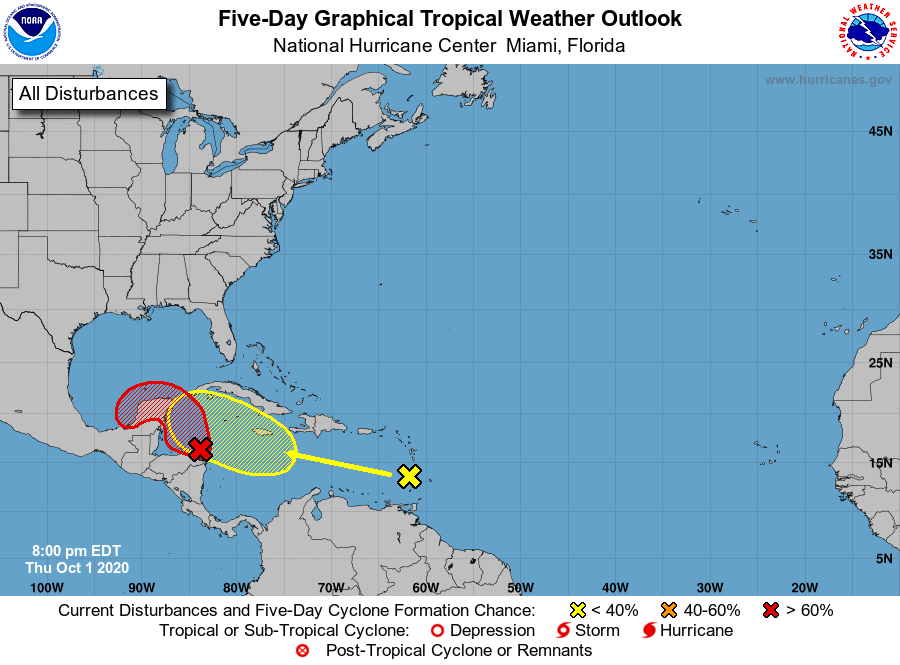
1. A broad area of low pressure has developed over the west-central
Caribbean Sea just north of the northeastern coast of Honduras.
Satellite images indicate that showers and thunderstorms are slowly
becoming better organized, and a NOAA buoy northeast of the center
has reported winds to near tropical storm force during the past few
hours.  Environmental conditions are expected to be conducive for a
tropical depression or a tropical storm to form on Friday or
Saturday, but only if the system moves and remains over the waters
of the northwestern Caribbean Sea or southern Gulf of Mexico.
Development will become less likely if the system moves over the
Yucatan Peninsula or northern Central America.  Regardless of
development, this system is expected to produce locally heavy rains,
with possible flash flooding, over portions of southeastern Mexico,
Central America, and western Cuba during the next several days, and
interests in those areas should monitor the progress of this
disturbance.  An Air Force Reserve reconnaissance aircraft is
scheduled to investigate the system tomorrow afternoon, if
necessary.
* Formation chance through 48 hours...high...70 percent.
* Formation chance through 5 days...high...80 percent.

2. Another tropical wave moving across the Lesser Antilles is producing
a large area of disorganized showers and thunderstorms, accompanied
by locally rainfall and gusty winds.  This wave is forecast to move
westward at 15 to 20 mph during the next several days, and
environmental conditions could become a little more conducive for
development when the system is over the central or western Caribbean
Sea early next week.
* Formation chance through 48 hours...low...near 0 percent.
* Formation chance through 5 days...low...30 percent.

Forecaster Stewart


