ZCZC MIATWOEP ALL
TTAA00 KNHC DDHHMM
Tropical Weather Outlook
NWS National Hurricane Center Miami FL
1100 AM PDT Thu Nov 1 2018
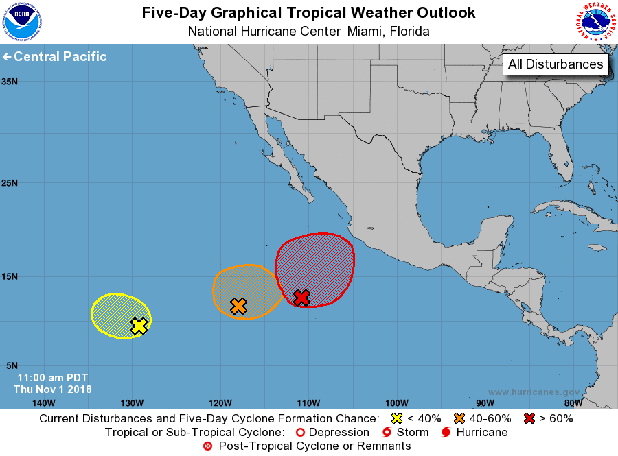
For the eastern North Pacific...east of 140 degrees west longitude:
1. Shower activity associated with an area of low pressure centered
about 700 miles south of the southern tip of the Baja California
Peninsula has become better organized during the past several
hours. Environmental conditions are forecast to be conducive for
additional development during the next several days, and a tropical
depression is likely to form during the next few days while the
system moves slowly northward or northeastward.
* Formation chance through 48 hours...high...70 percent.
* Formation chance through 5 days...high...90 percent.
2. Showers and thunderstorms associated with a broad area of low
pressure located about 1500 miles southwest of the southern tip of
the Baja California peninsula remain disorganized. Any development
during the next few days should be slow to occur while the
disturbance moves toward the west or west-northwest at 5 to 10 mph.
* Formation chance through 48 hours...low...10 percent.
* Formation chance through 5 days...low...10 percent.
3. An area of disturbed weather is located about 1000 miles southwest
of the southern tip of the Baja California peninsula. Some
development of this system is possible, although it could be limited
due to the proximity of the disturbance to the east.
* Formation chance through 48 hours...low...20 percent.
* Formation chance through 5 days...medium...40 percent.
Forecaster Beven