ZCZC MIATWOAT ALL
TTAA00 KNHC DDHHMM
Tropical Weather Outlook
NWS National Hurricane Center Miami FL
800 PM EDT Thu Sep 20 2018
For the North Atlantic...Caribbean Sea and the Gulf of Mexico:
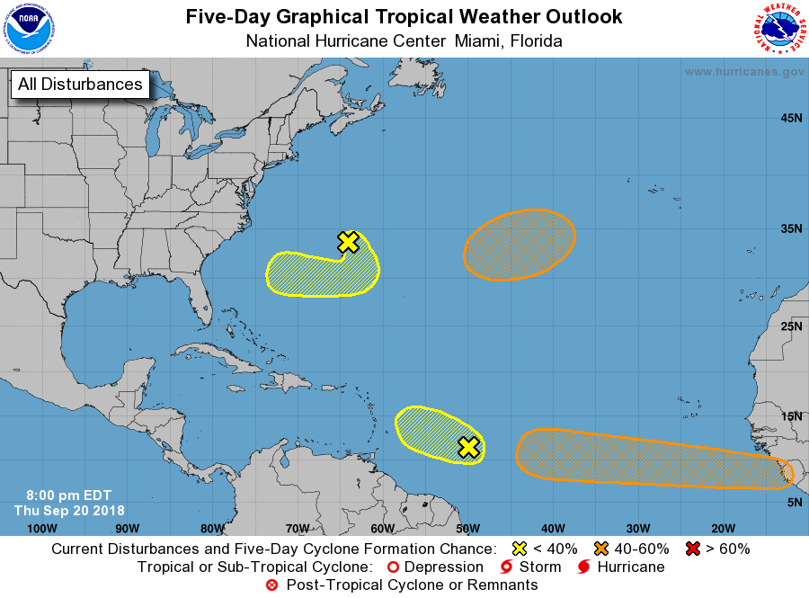
1. A small but concentrated area of showers and thunderstorms
associated with a tropical wave is located about 650 miles east of
the Windward Islands. The combination of dry mid-level air and
strong upper-level winds are expected to hinder any development of
this disturbance while it moves westward to west-northwestward at
10 to 15 mph.
* Formation chance through 48 hours...low...10 percent.
* Formation chance through 5 days...low...10 percent.
2. A non-tropical area of low pressure with gale-force winds, located
about 100 miles north-northeast of Bermuda, is moving southeastward
at about 15 mph. The combination of dry air associated with a
weakening frontal system and strong upper-level winds are expected
to inhibit any significant development for the next couple of days.
However, conditions could become a bit more conducive for this low
to gradually acquire some tropical characteristics early next week
while the system moves southward on Sunday, and then drifts westward
to the southwest of Bermuda on Monday.
* Formation chance through 48 hours...low...10 percent.
* Formation chance through 5 days...low...20 percent.
3. Another non-tropical low pressure system is forecast to develop
by Friday night over the central subtropical Atlantic Ocean midway
between Bermuda and the Azores. Conditions are expected to be
conducive for the low to acquire some subtropical or tropical
characteristics, and a subtropical or tropical cyclone could form
late this weekend or early next week while the low meanders over the
central Atlantic Ocean.
* Formation chance through 48 hours...low...near 0 percent.
* Formation chance through 5 days...medium...60 percent.
4. A tropical wave is moving off the coast of Guinea in western Africa.
Some slow but gradual development of this system is possible during
the next several days as the disturbance moves westward at 15 to 20
mph across the low latitudes of the eastern tropical Atlantic Ocean.
* Formation chance through 48 hours...low...10 percent.
* Formation chance through 5 days...medium...40 percent.
Forecaster Stewart