ZCZC MIATWOAT ALL
TTAA00 KNHC DDHHMM
Tropical Weather Outlook
NWS National Hurricane Center Miami FL
200 AM EDT Sat Jul 2 2022
For the North Atlantic...Caribbean Sea and the Gulf of Mexico:
Active Systems:
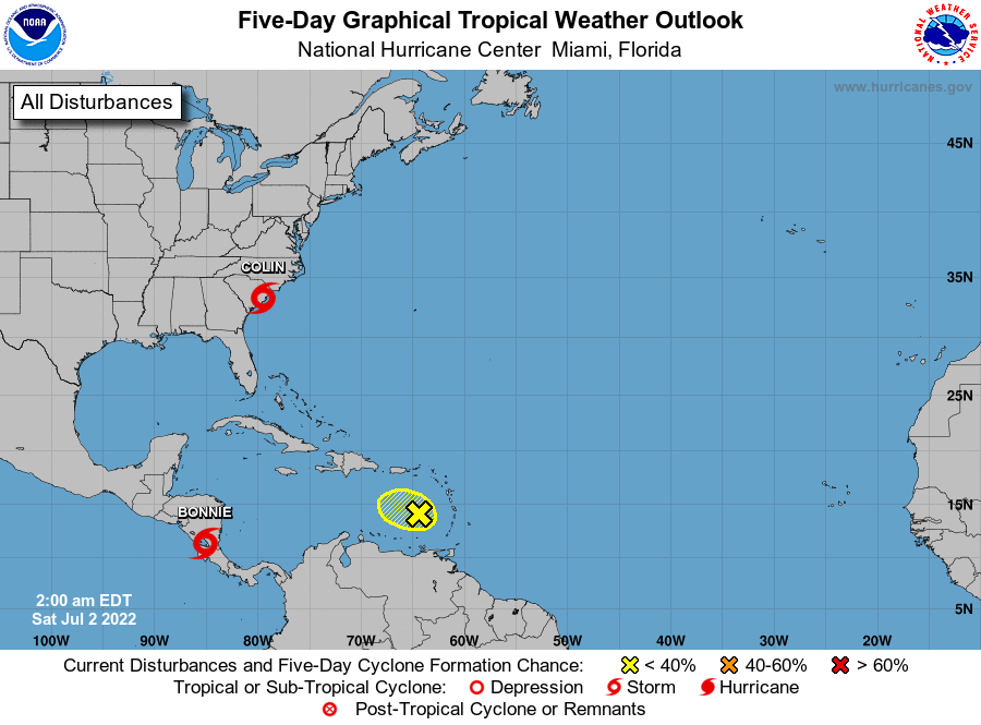
The National Hurricane Center is issuing advisories on Tropical
Storm Bonnie, located inland near the Nicaragua/Costa Rica border.
1. Near the South Carolina Coast:
Surface observations and satellite-derived wind data indicate that
the small low pressure system located along the coast of South
Carolina is producing sustained tropical-storm-force winds
primarily to the southeast of its center over water and near the
immediate coast. In addition, shower and thunderstorm activity has
persisted near the area of low pressure over the last 6 to 12 hours.
If the associated showers and thunderstorms persist and continue to
become better organized, then this system could become a tropical
storm later today while moving northeastward along the South
Carolina coast, and then reaching the North Carolina coast by
tonight. Regardless of development, this system is expected to
produce heavy rains, which could cause flash flooding across coastal
portions of the Carolinas over the weekend. See products issued by
the Weather Prediction Center and your local National Weather
Service forecast office for more details. Further information on
the system, including offshore gale warnings, can be found in High
Seas forecasts issued by the National Weather Service.
* Formation chance through 48 hours...medium...60 percent.
* Formation chance through 5 days...medium...60 percent.
2. Eastern Caribbean Sea:
A tropical wave located over the eastern Caribbean Sea continues
to produce a broad area of disorganized showers and thunderstorms
over the Windward Islands. Upper-level winds are not conducive for
significant development as the system moves west-northwestward
during the next few days across the Caribbean Sea.
* Formation chance through 48 hours...low...10 percent.
* Formation chance through 5 days...low...10 percent.
For more information on the system near Carolina coast, see products
issued by the National Weather Service at weather.gov and
wpc.ncep.noaa.gov
High Seas Forecasts issued by the National Weather Service can be
found under AWIPS header NFDHSFAT1, WMO header FZNT01 KWBC, and
online at ocean.weather.gov/shtml/NFDHSFAT1.php
Forecaster Papin