


NHC Graphical Outlook Archive
« Earliest Available ‹ Earlier Later › Latest Available »
Place your mouse cursor over areas of interest for more information
| GIS data: .shp |
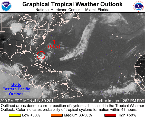
ZCZC MIATWOAT ALL
TTAA00 KNHC DDHHMM

TROPICAL WEATHER OUTLOOK
NWS NATIONAL HURRICANE CENTER MIAMI FL
200 PM EDT MON JUN 30 2014

For the North Atlantic...Caribbean Sea and the Gulf of Mexico:

1. Shower and thunderstorm activity has increased in association with
a low pressure area located about 125 miles east of Melbourne,
Florida.  Environmental conditions are becoming more conducive for
development, and only a slight increase in organization would result
in the formation of a tropical depression.  This system is moving
southwestward at around and 5 mph but is expected to turn westward
tonight and northward by Wednesday near the east Florida coast.  A
turn toward the northeast near the southeastern U.S. coast is
expected by Thursday. An Air Force Reserve reconnaissance aircraft
is en route to investigate the disturbance.  If this system becomes
a tropical cyclone, a tropical storm watch could be required for
portions of the central or northern Atlantic coast of Florida.
* Formation chance through 48 hours...high...80 percent.
* Formation chance through 5 days...high...80 percent.

Forecaster Kimberlain/Franklin
List of all Atlantic Outlooks
List of all East Pacific Outlooks