


NHC Graphical Outlook Archive
« Earliest Available ‹ Earlier Later › Latest Available »
Place your mouse cursor over areas of interest for more information
| GIS data: .shp |
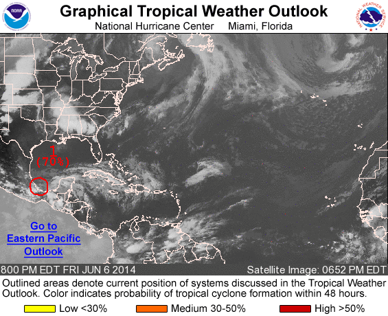
ZCZC MIATWOAT ALL
TTAA00 KNHC DDHHMM

TROPICAL WEATHER OUTLOOK
NWS NATIONAL HURRICANE CENTER MIAMI FL
800 PM EDT FRI JUN 6 2014

For the North Atlantic...Caribbean Sea and the Gulf of Mexico:

1. Satellite imagery and surface observations indicate that the
center of a well-defined low pressure system is located along the
coast of eastern Mexico near Vera Cruz. Associated shower activity
has been gradually increasing over the past few hours, and an Air
Force Reserve reconnaissance aircraft investigating the disturbance
has reported surface winds of 30 to 35 mph to the northeast and
east of the center thus far. If thunderstorm activity persists near
the low center, a tropical depression could still form before the
system moves slowly inland over eastern Mexico later tonight and
tomorrow. Whether or not a tropical depression forms, this
disturbance will produce gusty winds and heavy rains, along with
life-threatening flash floods and mud slides, over portions of
southeastern and eastern Mexico during the next few days.
* Formation chance through 48 hours...high...70 percent.
* Formation chance through 5 days...high...70 percent.

Forecaster Stewart
List of all Atlantic Outlooks
List of all East Pacific Outlooks