Skip Navigation Links
NOAA NOAA United States Department of Commerce

Top News of the Day... view past news
Last update Wed, 08 Oct 2025 23:36:22 UTC
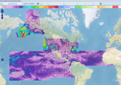
Central Pacific Eastern Pacific Atlantic

View 2-Day Graphical Tropical Weather Outlook with Satellite
Click for Eastern Pacific
Active Storms | Marine Forecasts
Tropical Atlantic Full Basin Gulf of America Atlantic Offshore Waters Caribbean Tropical East Pacific Forecast Graphics Tropical East Pacific Full Basin Mexico Offshore Waters Central America Offshore Waters North Atlantic Marine Forecasts

Atlantic - Caribbean Sea - Gulf of America
Tropical Weather Outlook (en Español*)
200 PM EDT Wed Oct 8 2025
Tropical Weather Discussion
0015 UTC Thu Oct 9 2025
TC Type ImageTropical Storm Jerry RSS Feed icon Satellite | Buoys | Grids | Storm Archive
...TROPICAL STORM CONDITIONS POSSIBLE ON PORTIONS OF THE NORTHERN LEEWARD ISLANDS WHEN JERRY PASSES NEARBY LATE THURSDAY AND THURSDAY NIGHT...
5:00 PM AST Wed Oct 08
Location: 14.8°N 54.7°W
Moving: WNW at 23 mph
Min pressure: 1000 mb
Max sustained: 60 mph

Public
Advisory
#6

500 PM AST
Forecast
Advisory
#6

2100 UTC
Forecast
Discussion
#6

500 PM AST
Wind Speed
Probabilities
#6

2100 UTC
 
Productos en español:
(más información)

Aviso
Publico

Pronóstico
Discusión

34-knot Wind Speed Probability
Wind Speed
Probabilities
Earliest Reasonable Time of Arrival of 34-knot winds
Arrival Time
of Winds
Wind History
Wind
History
Google Maps API Warnings and Track Forecast Cone
Warnings/Cone
Interactive Map
Warnings and 5-Day Cone
Warnings/Cone
Static Images
Experimental Cone
Experimental
Cone
Surface Wind Field
Warnings and
Surface Wind
Key Messages
Key
Messages
Mensajes Claves
Mensajes
Claves
Rip Currents
Rip
Currents
WPC Rainfall Potential thumbnail
Rainfall
Potential


Eastern North Pacific (East of 140°W)
Tropical Weather Outlook (en Español*)
500 PM PDT Wed Oct 8 2025
Tropical Weather Discussion
2205 UTC Wed Oct 8 2025
TC Type ImageTropical Storm Priscilla RSS Feed icon Satellite | Buoys | Grids | Storm Archive
...PRISCILLA MOVING NORTHWESTWARD AND BRINGING HIGH SURF AND GUSTY WINDS TO THE PACIFIC COAST OF BAJA CALIFORNIA SUR... ...MOISTURE FROM PRISCILLA WILL INCREASE THE RISK OF FLOODING ACROSS THE U.S. DESERT SOUTHWEST LATE THIS WEEK THROUGH THE WEEKEND...
5:00 PM MST Wed Oct 08
Location: 22.3°N 113.3°W
Moving: NW at 8 mph
Min pressure: 986 mb
Max sustained: 65 mph

Public
Advisory
#17A

500 PM MST
Forecast
Advisory
#17

2100 UTC
Forecast
Discussion
#17

200 PM MST
Wind Speed
Probabilities
#17

2100 UTC
 
Productos en español:
(más información)

Aviso
Publico

Pronóstico
Discusión

34-knot Wind Speed Probability
Wind Speed
Probabilities
Earliest Reasonable Time of Arrival of 34-knot winds
Arrival Time
of Winds
Wind History
Wind
History
Google Maps API Warnings and Track Forecast Cone
Warnings/Cone
Interactive Map
Warnings and 5-Day Cone
Warnings/Cone
Static Images
Experimental Cone
Experimental
Cone
Surface Wind Field
Warnings and
Surface Wind
Key Messages
Key
Messages
Mensajes Claves
Mensajes
Claves
Rip Currents
Rip
Currents
WPC Rainfall Potential thumbnail
Rainfall
Potential
WPC Flash Flooding Potential thumbnail
Flash Flooding
Potential
TC Type ImageTropical Storm Octave RSS Feed icon Satellite | Buoys | Grids | Storm Archive
...OCTAVE STILL A TROPICAL STORM BUT LIKELY TO DISSIPATE ON THURSDAY...
2:00 PM PDT Wed Oct 08
Location: 15.8°N 115.1°W
Moving: ENE at 12 mph
Min pressure: 1002 mb
Max sustained: 45 mph

Public
Advisory
#35

200 PM PDT
Forecast
Advisory
#35

2100 UTC
Forecast
Discussion
#35

200 PM PDT
Wind Speed
Probabilities
#35

2100 UTC
 
Productos en español:
(más información)

Aviso
Publico

Pronóstico
Discusión

34-knot Wind Speed Probability
Wind Speed
Probabilities
Earliest Reasonable Time of Arrival of 34-knot winds
Arrival Time
of Winds
Wind History
Wind
History
Google Maps API Warnings and Track Forecast Cone
Warnings/Cone
Interactive Map
Warnings and 5-Day Cone
Warnings/Cone
Static Images
Experimental Cone
Experimental
Cone
Surface Wind Field
Warnings and
Surface Wind
Rip Currents
Rip
Currents


Central North Pacific (140°W to 180°)
Tropical Weather Outlook (en Español*)
200 PM HST Wed Oct 08 2025
There are no tropical cyclones in the Central Pacific at this time.