-
- Be Prepared!
NWS Hurricane
Prep Week - NWS Hurricane Safety
- Outreach Documents
- TC Videos
- Rip Currents
- Storm Surge
- Watch/Warning Breakpoints
- Climatology
- Tropical Cyclone Names
- Wind Scale
- Records and Facts
- Historical Hurricane Summaries
- Forecast Models
- NHC Publications
- NHC Glossary
- Acronyms
- Frequent Questions
- Be Prepared!
-
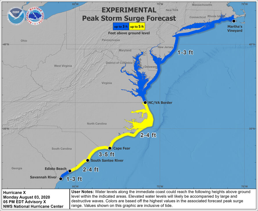
Peak Storm Surge Forecast
The Peak Storm Surge Graphic depicts the expected storm surge inundation values for the United States Gulf and Atlantic coasts, Puerto Rico, and the U.S. Virgin Islands that are provided in the tropical cyclone public advisory (TCP). These values represent the peak height the water could reach above normally dry ground somewhere within the specified areas. This graphic will be made available on the NHC webpage.

Tropical Cyclone Advisories
Tropical Weather Outlook
Audio/Podcasts
About Advisories
Marine Forecasts
Offshore Waters Forecasts
Gridded Forecasts
Graphicast
About Marine
"Inside the Eye"
Hurricane Preparedness
Preparedness Guide
Hurricane Hazards
Watches and Warnings
Marine Safety
Ready.gov Hurricanes | en Español
Weather-Ready Nation
Emergency Management Offices
US Dept of Commerce
National Oceanic and Atmospheric Administration
National Hurricane Center
11691 SW 17th Street
Miami, FL, 33165
nhcwebmaster@noaa.gov
Central Pacific Hurricane Center
2525 Correa Rd
Suite 250
Honolulu, HI 96822
W-HFO.webmaster@noaa.gov


