ZCZC MIATWOAT ALL
TTAA00 KNHC DDHHMM
Tropical Weather Outlook
NWS National Hurricane Center Miami FL
100 AM EST Mon Nov 7 2022
For the North Atlantic...Caribbean Sea and the Gulf of Mexico:
1. Southwestern Atlantic:
Recent satellite-derived wind data and reports from a NOAA buoy
indicate that the center of a low pressure system located more than
300 miles northeast of the southeastern Bahamas is becoming better
defined, and the system is producing an area of gale-force winds
well to the east of its center. In addition, the associated shower
and thunderstorm activity is beginning to show signs of
organization. Environmental conditions appear conducive for
additional development, and a subtropical or tropical storm is
expected to form later today or tonight while moving slowly
northwestward over the southwestern Atlantic. The system is then
forecast to turn westward and west-southwestward on Tuesday and
Wednesday, approaching and moving near the northwestern Bahamas and
the east coast of Florida, where additional development is possible.
Regardless of development, the risk continues to increase for a
prolonged period of coastal flooding, tropical-storm-force winds,
heavy rainfall, rough surf and rip currents, and beach erosion along
the southeastern United States coast, the Florida east coast, and
portions of the central and northwestern Bahamas during much of the
upcoming week. Interests in those areas should continue to monitor
the progress of this system as tropical storm, hurricane, and storm
surge watches could be required for a portion of these areas later
today. Additional information on this system, including gale
warnings, can be found in High Seas Forecasts issued by the National
Weather Service and in products from your local weather office.
* Formation chance through 48 hours...high...90 percent.
* Formation chance through 5 days...high...90 percent.
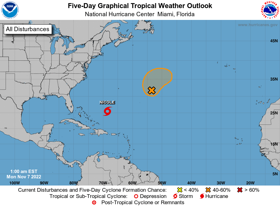
2. Central Subtropical Atlantic:
A well-defined area of low pressure located about 650 miles east of
Bermuda continues to produce gale-force winds, but the associated
shower and thunderstorm activity is displaced to the east of the
low's center due to strong upper-level winds. Upper-level winds are
expected to remain unfavorable for development while the system
moves northward and then northeastward at about 10 mph, but a
short-lived tropical storm could still form later today or on
Tuesday before the low dissipates and merges with a cold front.
Additional information on this system, including gale warnings, can
be found in High Seas Forecasts issued by the National Weather
Service.
* Formation chance through 48 hours...medium...60 percent.
* Formation chance through 5 days...medium...60 percent.
High Seas Forecasts issued by the National Weather Service
can be found under AWIPS header NFDHSFAT1, WMO header FZNT01
KWBC, and online at ocean.weather.gov/shtml/NFDHSFAT1.php
Forecaster Berg