ZCZC MIATWOAT ALL
TTAA00 KNHC DDHHMM
Tropical Weather Outlook
NWS National Hurricane Center Miami FL
800 PM EDT Sun Sep 12 2021
For the North Atlantic...Caribbean Sea and the Gulf of Mexico:
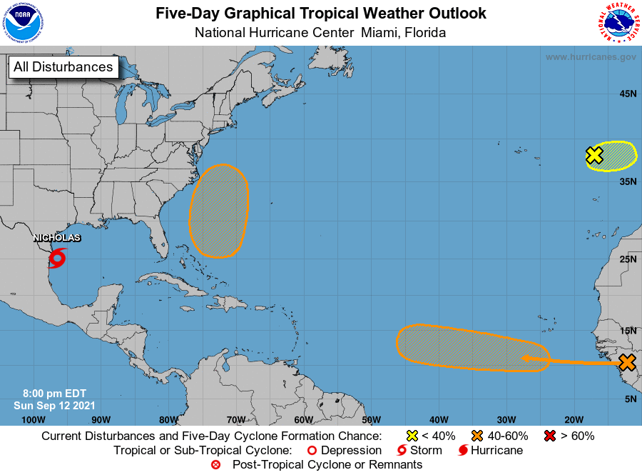
The National Hurricane Center is issuing advisories on Tropical
Storm Nicholas, located over the southwestern Gulf of Mexico.
1. A tropical wave is expected to emerge off the west coast of Africa
on Monday. Environmental conditions are forecast to be conducive
for some gradual development of this system thereafter, and a
tropical depression could form later this week while it moves
westward at 10 to 15 mph across the eastern tropical Atlantic Ocean.
* Formation chance through 48 hours...low...20 percent.
* Formation chance through 5 days...medium...60 percent.
2. Showers and thunderstorms are very limited in association with a
non-tropical area of low pressure over the far northeastern
Atlantic, located a few hundred miles east of the Azores.
Significant development of this system appears unlikely during the
next day or so while it moves slowly eastward. By late Tuesday, the
system is forecast to move inland over Portugal.
* Formation chance through 48 hours...low...10 percent.
* Formation chance through 5 days...low...10 percent.
3. An area of low pressure is forecast to form by midweek a couple of
hundred miles north of the southeastern or central Bahamas as a
tropical wave interacts with an upper-level trough. Some gradual
development of this system is possible thereafter, and a tropical
depression could form later this week while the system moves
north-northwestward or northward across the western Atlantic.
* Formation chance through 48 hours...low...near 0 percent.
* Formation chance through 5 days...medium...50 percent.
Public Advisories on Tropical Storm Nicholas are issued under
WMO header WTNT34 KNHC and under AWIPS header MIATCPAT4.
Forecast/Advisories on Tropical Storm Nicholas are issued under
WMO header WTNT24 KNHC and under AWIPS header MIATCMAT4.
Forecaster Reinhart