ZCZC MIATWOAT ALL
TTAA00 KNHC DDHHMM

TROPICAL WEATHER OUTLOOK
NWS NATIONAL HURRICANE CENTER MIAMI FL
200 PM EDT SAT JUL 30 2016

For the North Atlantic...Caribbean Sea and the Gulf of Mexico:

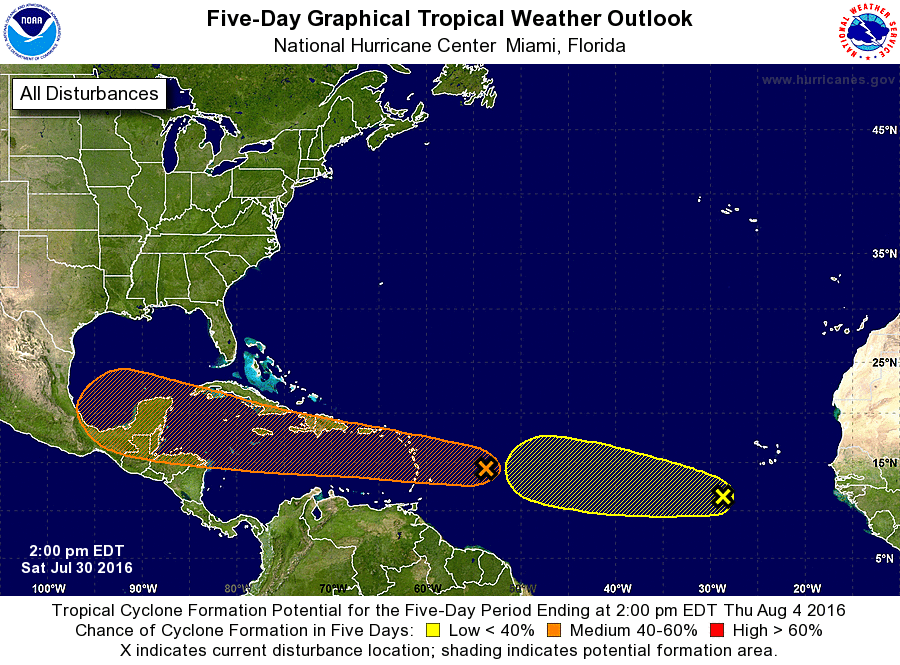
1. A strong tropical wave located about 550 miles east of the Lesser
Antilles is moving westward at 25 to 30 mph and is accompanied by
increasing shower activity.  However, surface observations and
satellite wind data show that pressures are relatively high in the
area and that there are no signs of a circulation.  During the next
day or two, development should be slow to occur due to the rapid
motion of the system. Regardless of development, this system will
likely bring locally heavy rains and gusty winds to portions of the
Leeward Islands, Virgin Islands, Puerto Rico, and Hispaniola, and
interests in these areas should monitor its progress.  By the middle
of next week, the disturbance is expected to be in the western
Caribbean Sea, where conditions are likely to be more conducive for
development.
* Formation chance through 48 hours...low...30 percent
* Formation chance through 5 days...medium...60 percent

2. Shower and thunderstorm activity associated with a tropical wave
and a low pressure system centered about 400 miles southwest of Cabo
Verde continues to lose organization.  Development of this system
is becoming less likely due to unfavorable upper-level winds.
* Formation chance through 48 hours...low...20 percent
* Formation chance through 5 days...low...20 percent

Forecaster Beven


