


NHC Graphical Outlook Archive
|
« Earliest Available ‹ Earlier Later › Latest Available » |
| Eastern Pacific | Atlantic |
|
|
(mouse over weather symbols for details; click on weather symbols or disturbance numbers to switch views) |
Tropical Weather Outlook Text
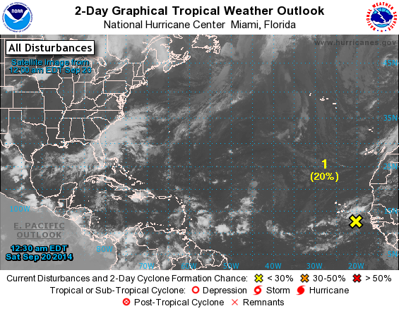
TROPICAL WEATHER OUTLOOK
NWS NATIONAL HURRICANE CENTER MIAMI FL
800 PM EDT FRI SEP 19 2014

For the North Atlantic...Caribbean Sea and the Gulf of Mexico:

The National Hurricane Center has issued the last advisory on
Post-Tropical Cyclone Edouard, located a few hundred miles west of
the western Azores. Additional information on Edouard can be found
in High Seas Forecasts issued by the National Weather Service.

1. Disorganized showers and thunderstorms are associated with a broad
area of low pressure located a couple hundred miles southeast of the
Cape Verde Islands. While some development of this system is
possible during the next day or two, upper-level winds are expected
to become less conducive after that time. This low should move
generally northwestward and could bring heavy rainfall to portions
of the Cape Verde Islands this weekend.
* Formation chance through 48 hours...low...20 percent.
* Formation chance through 5 days...low...20 percent.

High Seas Forecasts issued by the National Weather Service can be
found under AWIPS header NFDHSFAT1 and WMO header FZNT01 KWBC.

Forecaster Landsea
List of Atlantic Outlooks (May 2023 - present)
List of East Pacific Outlooks (May 2023 - present)
List of Central Pacific Outlooks (May 2023 - present)
List of Atlantic Outlooks (July 2014 - April 2023)
List of East Pacific Outlooks (July 2014 - April 2023)
List of Central Pacific Outlooks (June 2019 - April 2023)
List of Atlantic Outlooks (June 2009 - June 2014)
List of East Pacific Outlooks (June 2009 - June 2014)