


NHC Graphical Outlook Archive
|
« Earliest Available ‹ Earlier Later › Latest Available » |
| Eastern Pacific | Atlantic |
|
|
(mouse over shaded areas for details; click on shaded areas or disturbance numbers to switch views) |
Tropical Weather Outlook Text
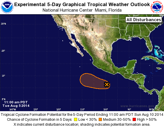
TROPICAL WEATHER OUTLOOK
NWS NATIONAL HURRICANE CENTER MIAMI FL
1100 AM PDT TUE AUG 5 2014

For the eastern North Pacific...east of 140 degrees west longitude:

The National Hurricane Center has issued its last advisory on
Hurricane Iselle located more than a thousand miles east of the
Hawaiian Islands.  Future advisories will be issued by the Central
Pacific Hurricane Center in Honolulu, Hawaii.  The National
Hurricane Center is issuing advisories on Tropical Storm Julio,
located more than a thousand miles southwest of the southern tip of
the Baja California peninsula.

1. A small low pressure system is located several hundred miles south
of Acapulco, Mexico.  While shower and thunderstorm activity has
changed little in organization during the past several hours,
upper-level winds could become more conducive for development over
the next few days while the system moves west-northwestward at 10 to
15 mph.
* Formation chance through 48 hours...medium...30 percent.
* Formation chance through 5 days...medium...30 percent.

Forecaster Beven
List of Atlantic Outlooks (May 2023 - present)
List of East Pacific Outlooks (May 2023 - present)
List of Central Pacific Outlooks (May 2023 - present)
List of Atlantic Outlooks (July 2014 - April 2023)
List of East Pacific Outlooks (July 2014 - April 2023)
List of Central Pacific Outlooks (June 2019 - April 2023)
List of Atlantic Outlooks (June 2009 - June 2014)
List of East Pacific Outlooks (June 2009 - June 2014)