


NHC Graphical Outlook Archive
|
« Earliest Available ‹ Earlier Later › Latest Available » |
| Eastern Pacific | Atlantic |
|
|
(mouse over shaded areas for details; click on shaded areas or disturbance numbers to switch views) |
Tropical Weather Outlook Text
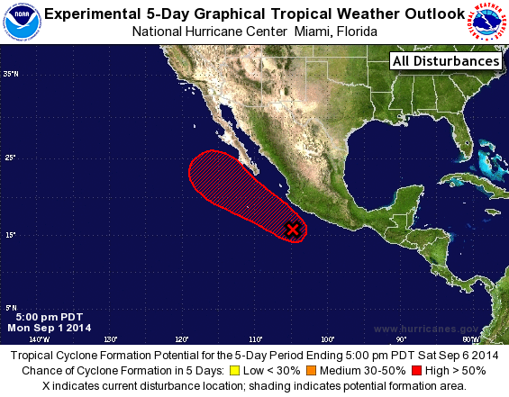
TROPICAL WEATHER OUTLOOK
NWS NATIONAL HURRICANE CENTER MIAMI FL
500 PM PDT MON SEP 1 2014

For the eastern North Pacific...east of 140 degrees west longitude:

1. A large area of showers and thunderstorms near the southwestern
coast of Mexico is associated with a trough of low pressure.
Environmental conditions are expected to be conducive for gradual
development of this system, and a tropical depression is likely to
form later this week.  This disturbance is expected to move slowly
northward and then northwestward and could produce locally heavy
rains over portions of southwestern Mexico during the next few
days.  These rains could cause life-threatening flash floods and mud
slides.
* Formation chance through 48 hours...medium...30 percent.
* Formation chance through 5 days...high...80 percent.

Forecaster Cangialosi
List of Atlantic Outlooks (May 2023 - present)
List of East Pacific Outlooks (May 2023 - present)
List of Central Pacific Outlooks (May 2023 - present)
List of Atlantic Outlooks (July 2014 - April 2023)
List of East Pacific Outlooks (July 2014 - April 2023)
List of Central Pacific Outlooks (June 2019 - April 2023)
List of Atlantic Outlooks (June 2009 - June 2014)
List of East Pacific Outlooks (June 2009 - June 2014)