


NHC Graphical Outlook Archive
|
« Earliest Available ‹ Earlier Later › Latest Available » |
| Eastern Pacific | Atlantic |
|
|
(mouse over weather symbols for details; click on weather symbols or disturbance numbers to switch views) |
Tropical Weather Outlook Text
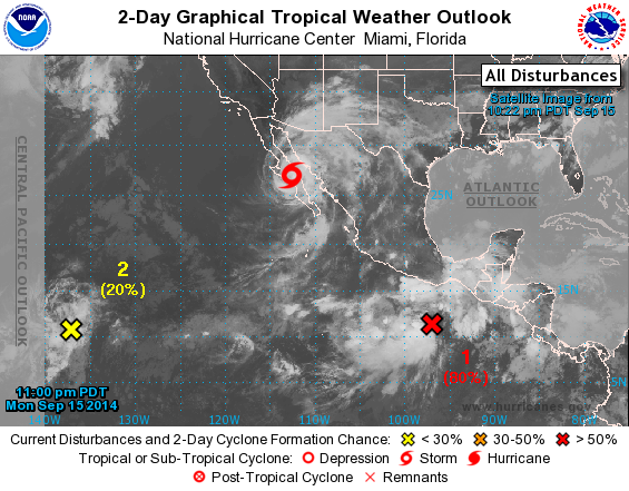
TROPICAL WEATHER OUTLOOK
NWS NATIONAL HURRICANE CENTER MIAMI FL
1100 PM PDT MON SEP 15 2014

For the eastern North Pacific...east of 140 degrees west longitude:

The National Hurricane Center is issuing advisories on Tropical
Storm Odile, located inland over the south-central portion of the
Baja California peninsula.

1. An elongated low pressure area located several hundred miles
south-southeast of Acapulco, Mexico, continues to produce a
large area of showers and thunderstorms.  Environmental conditions
are conducive for development, and this disturbance is likely
to become a tropical depression during the next day or two while it
moves west-northwestward or northwestward at about 10 mph.
* Formation chance through 48 hours...high...80 percent.
* Formation chance through 5 days...high...90 percent.

2. Cloudiness and thunderstorms associated with a small area of low
pressure located about 1300 miles east-southeast of the Big Island
of Hawaii have changed little in organization this evening. Some
gradual development of this system is possible during the next
several days while the low moves slowly west-northwestward or
northwestward.
* Formation chance through 48 hours...low...20 percent.
* Formation chance through 5 days...medium...30 percent.

Forecaster Brown
List of Atlantic Outlooks (May 2023 - present)
List of East Pacific Outlooks (May 2023 - present)
List of Central Pacific Outlooks (May 2023 - present)
List of Atlantic Outlooks (July 2014 - April 2023)
List of East Pacific Outlooks (July 2014 - April 2023)
List of Central Pacific Outlooks (June 2019 - April 2023)
List of Atlantic Outlooks (June 2009 - June 2014)
List of East Pacific Outlooks (June 2009 - June 2014)