


NHC Graphical Outlook Archive
|
« Earliest Available ‹ Earlier Later › Latest Available » |
| Eastern Pacific | Atlantic |
|
|
(mouse over weather symbols for details; click on weather symbols or disturbance numbers to switch views) |
Tropical Weather Outlook Text
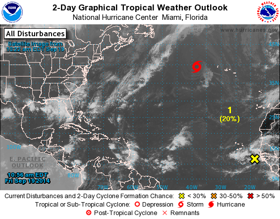
TROPICAL WEATHER OUTLOOK
NWS NATIONAL HURRICANE CENTER MIAMI FL
800 AM EDT FRI SEP 19 2014

For the North Atlantic...Caribbean Sea and the Gulf of Mexico:

The National Hurricane Center is issuing advisories on Tropical
Storm Edouard, located several hundred miles west-northwest of the
western Azores.

1. Disorganized showers and thunderstorms continue in association
with a broad area of low pressure located between the west coast of
Africa and the Cape Verde Islands.  Some development of this system
is possible over the next few days before upper-level winds become
less conducive.  This low is expected to move slowly west-
northwestward or northwestward and could bring heavy rainfall to
portions of the Cape Verde Islands this weekend.
* Formation chance through 48 hours...low...20 percent.
* Formation chance through 5 days...medium...30 percent.

2. An area of low pressure is expected to form off of the southeastern
coast of the United States over the weekend.  The system is now
expected to remain non-tropical (frontal) while it accelerates
northeastward a short distance off of the U.S. east coast.
* Formation chance through 48 hours...low...near 0 percent.
* Formation chance through 5 days...low...near 0 percent.

Forecaster Kimberlain
List of Atlantic Outlooks (May 2023 - present)
List of East Pacific Outlooks (May 2023 - present)
List of Central Pacific Outlooks (May 2023 - present)
List of Atlantic Outlooks (July 2014 - April 2023)
List of East Pacific Outlooks (July 2014 - April 2023)
List of Central Pacific Outlooks (June 2019 - April 2023)
List of Atlantic Outlooks (June 2009 - June 2014)
List of East Pacific Outlooks (June 2009 - June 2014)