ZCZC MIATWOAT ALL
TTAA00 KNHC DDHHMM
Tropical Weather Outlook
NWS National Hurricane Center Miami FL
800 PM EDT Tue Sep 3 2024
For the North Atlantic...Caribbean Sea and the Gulf of Mexico:
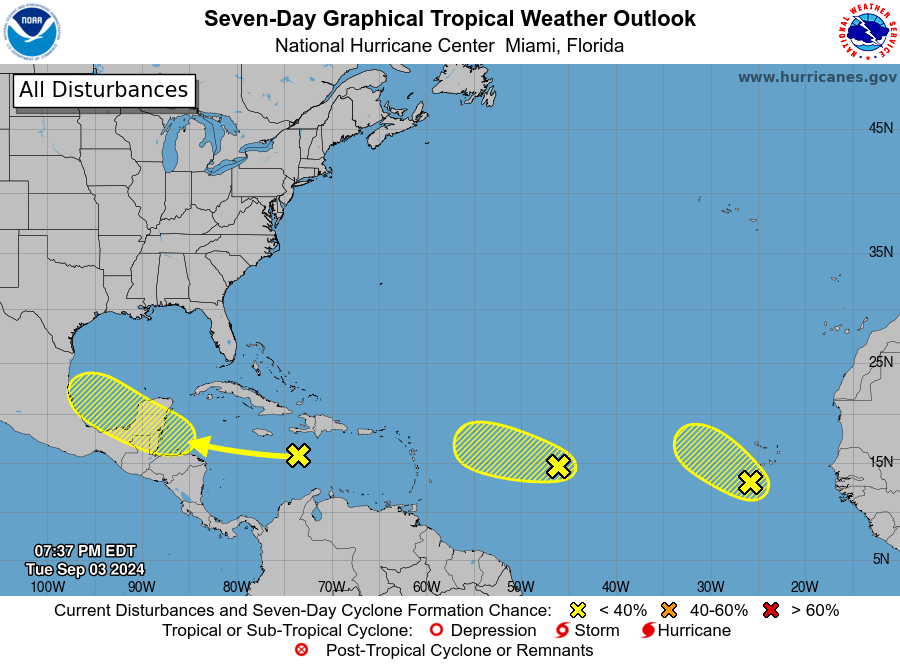
1. Northwestern Caribbean Sea and Southwestern Gulf of Mexico:
A tropical wave moving quickly westward at about 20 mph is
producing a large area of disorganized showers and thunderstorms
over Hispaniola and portions of the central Caribbean Sea. Some
development is possible late this week when the wave slows down
over the northwestern Caribbean Sea or early next week over the
southwestern Gulf of Mexico.
* Formation chance through 48 hours...low...near 0 percent.
* Formation chance through 7 days...low...30 percent.
2. Central Tropical Atlantic Ocean:
Another tropical wave located about a thousand miles east of the
Lesser Antilles is producing disorganized showers and thunderstorms.
Development of this system, if any, is expected to be slow to occur
over the next couple of days while it moves west-northwestward at
10 to 15 mph. Environmental conditions are expected to become
unfavorable for additional development by the end of the week.
* Formation chance through 48 hours...low...10 percent.
* Formation chance through 7 days...low...10 percent.
3. Eastern Tropical Atlantic Ocean:
A third tropical wave over the far eastern Atlantic is also
producing disorganized shower activity. Some slow development of
this system is possible during the next few days while it moves
slowly northwestward at 5 to 10 mph over the eastern tropical
Atlantic Ocean. Environmental conditions are expected to become
less conducive for development by the end of the week. This system
could produce locally heavy rains across portions of the Cabo Verde
Islands overnight and on Wednesday.
* Formation chance through 48 hours...low...20 percent.
* Formation chance through 7 days...low...30 percent.
Forecaster Berg