


NHC Graphical Outlook Archive
« Earliest Available ‹ Earlier Later › Latest Available »
Place your mouse cursor over areas of interest for more information
| GIS data: .shp |
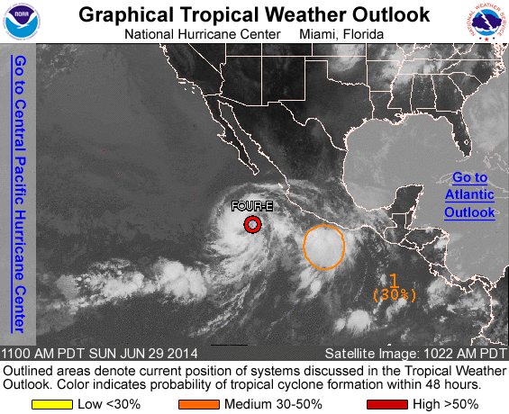
ZCZC MIATWOEP ALL
TTAA00 KNHC DDHHMM

TROPICAL WEATHER OUTLOOK
NWS NATIONAL HURRICANE CENTER MIAMI FL
1100 AM PDT SUN JUN 29 2014

For the eastern North Pacific...east of 140 degrees west longitude:

The National Hurricane Center is issuing advisories on Tropical
Depression Four-E, located several hundred miles west-southwest of
Manzanillo, Mexico.

1. Showers and thunderstorms have become more concentrated and better
organized in association with a weak low pressure area located a
couple of hundred miles south of Acapulco, Mexico, this morning. The
proximity of this disturbance to Tropical Depression Four-E could
limit development during the next day or two while the system moves
slowly west-northwestward to northwestward. However, environmental
conditions are expected to become favorable for slow development
after that time.
* Formation chance through 48 hours...medium...30 percent.
* Formation chance through 5 days...medium...50 percent.

Forecaster Kimberlain
List of all Atlantic Outlooks
List of all East Pacific Outlooks