NHC Graphical Outlook Archive
« Earliest Available ‹ Earlier Later › Latest Available »
Place your mouse cursor over areas of interest for more information

| GIS data: .shp |
ZCZC MIATWOEP ALL
TTAA00 KNHC DDHHMM cca

TROPICAL WEATHER OUTLOOK...corrected
NWS NATIONAL HURRICANE CENTER MIAMI FL
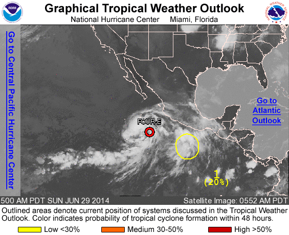
500 AM PDT SUN JUN 29 2014

corrected 48-hour category to low

For the eastern North Pacific...east of 140 degrees west longitude:

The National Hurricane Center is issuing advisories on Tropical
Depression Four-E, located several hundred miles southwest of
Manzanillo, Mexico.

1. A weak area of low pressure located a few hundred miles south-
southeast of Acapulco, Mexico, continues to produce disorganized
showers and thunderstorms as it moves west-northwestward to
northwestward at around 10 mph.  The proximity of this disturbance
to Tropical Depression Four-E may limit development during the next
couple of days, but environmental conditions are expected to become
favorable for slow development after that time.
* Formation chance through 48 hours...low...20 percent.
* Formation chance through 5 days...medium...50 percent.

Public Advisories on Tropical Depression Four-E are issued under WMO
header WTPZ34 KNHC and under AWIPS header MIATCPEP4.
Forecast/Advisories on Tropical Depression Four-E are issued under
WMO header WTPZ24 KNHC and under AWIPS header MIATCMEP4.

Forecaster Kimberlain
List of all Atlantic Outlooks
List of all East Pacific Outlooks


