


NHC Graphical Outlook Archive
« Earliest Available ‹ Earlier Later › Latest Available »
Place your mouse cursor over areas of interest for more information
| GIS data: .shp |
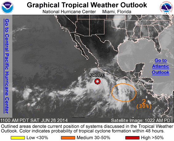
ZCZC MIATWOEP ALL
TTAA00 KNHC DDHHMM

TROPICAL WEATHER OUTLOOK
NWS NATIONAL HURRICANE CENTER MIAMI FL
1100 AM PDT SAT JUN 28 2014

For the eastern North Pacific...east of 140 degrees west longitude:

1. Satellite images indicate that showers and thunderstorms
associated with a low pressure area centered about 350 miles
south-southwest of Manzanillo, Mexico, are becoming better
organized.  Environmental conditions are very conducive for further
development and a tropical depression could form later today or
tonight while the system moves west-northwestward at about 10 mph.
* Formation chance through 48 hours...high...90 percent.
* Formation chance through 5 days...high...90 percent.

2. A small area of low pressure is located several hundred miles
south of the Gulf of Tehuantepec and is producing disorganized
showers and thunderstorms.  Some development of this system is
possible over the next few days while it moves west-northwestward
or northwestward at 10 to 15 mph.
* Formation chance through 48 hours...medium...30 percent.
* Formation chance through 5 days...medium...50 percent.

Forecaster Blake
List of all Atlantic Outlooks
List of all East Pacific Outlooks